Wit Poortje Nr. 16
16 op die kadaster · op rekord 1872 · wys op die kaart
- Plaasnommer
- Nr. 16
- Op die kadaster
- 16, heel plaasgeregistreer as WIT POORTJE
- Distrik
- Prince Albert
- Grootte, soos die kaart dit stel
- 5168 morgen 300 square roods (1872)
- Moderne opgemete oppervlakte
- 4407.8 ha
Die historiese grootte en die moderne opgemete oppervlakte is twee aparte metings en word hier nie aangebied asof hulle mekaar bevestig nie. Die eerste is wat 'n landmeter op 'n kaart geskryf het, gewoonlik in morg. Die tweede is wat die moderne kadaster teken.
Waarom hierdie plaas hier is
'n Stuk van 'n plaas wat reeds in hierdie model is. 42 km van Klaarstroom.
- perseel Grond uit hierdie plaas gesny: Wit Poortje Nr. 16 Gdlt 1 (formerly Gedeelte A)
- grens Deel 'n grens met Zeekoegate Zeekoegate
- grens Deel 'n grens met Trakas Kuilen Nr. 15 Trakas Kuilen Nr. 15
- dokument 'n Dokument in die versameling beskryf hierdie grond DOC-0258
- …en nog 1, volledig gelys verder af op hierdie bladsy.
Wat die rekord hou, in volgorde
-
1872
document
SG diagram 765/1873
P.A.Q.2-26
- 1872 document SG diagram verso 765/1873 (verso)
Grond uit hierdie plaas gesny
Begrens deur, soos die kaart hulle noem
- N Amos Poortje (1872)
- NE/SE Wolve Kraal (1872)
- S Zout Water (1872)
- SW Zeekoegat
- NW Trakas Kuilen
Op die afdelingskaart van 1915
Soos die Landmeter-generaal hierdie plaas in 1915 gedruk het: die geregistreerde titelhouer, die datum waarop die titel uitgereik is en die erfpagverwysing, net so van die kaart oorgeskryf. Die hele kaart, plaas vir plaas
| Plaas, soos gedruk | Titelhouer | Titel | Erfpag | Aantekening |
|---|---|---|---|---|
| WIT POORTJE | J. M. C. Horn & another | 1 July 1879 | P.A.Q. 2.26 · fol. [?1464] | full label here; see a1c4 |
Ook begrens deur, soos die moderne kadaster dit teken
Grond wat aan hierdie plaas raak op die Landmeter-generaal se huidige poligone en wat geen kaart wat hier gehou word, noem nie. Afgelei uit die meetkunde, nie van 'n dokument afgelees nie.
- NE Wit Poortje Nr. 16 Gdlt 1 (formerly Gedeelte A)
- E Wolwekraal Nr. 17
- SE Klipgat Nr. 114
- S Zoutwater (Klipgat Nr. 114 Gdlt 1)
- S Bontwater (Klipgat Nr. 114 Gdlt 8)
- SW Antjiesfontein (Leeukraal Nr. 24 Gdlt 1)
- W Leeukraal Nr. 24 (consolidated)
Dokumente
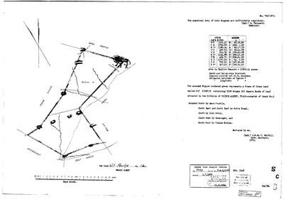 Landmeter-generaal-kaart, 765/1873, 1872
10FKU101 16 0.jpg
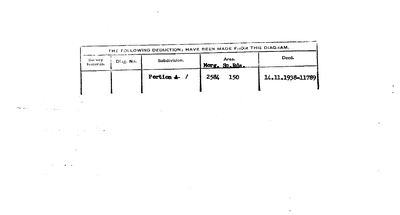 Kaart se keersy, 765/1873 (verso), 1872
10FKU801 16 0.jpg
Kadaster
Die Landmeter-generaal se kaartindeks vir hierdie perseel
Navorsingsnotas
[9 Aug 2026, SRC-342] A FARM THIS MODEL DID NOT HOLD, added from its own diagram. SG 765/1873: "The annexed Figure bordered green represents a Piece of CROWN LAND called WIT POORTJE containing 5168 Morgen 300 Square Roods of Land situated in the Division of PRINCE ALBERT, Field-cornetcy of GOUPH No.3", surveyed 1872 by J.W. du T. MELVILL, Government Surveyor, examined by L. MARQUARD. Bounded North by AMOS POORTJE, North East and South East by WOLVE KRAAL, South by ZOUT WATER, South West by ZEEKOEGAT, and North West by TRAKAS KUILEN. Titled P.A.Q.2-26 on 1 JULY 1879.
THE SHEET CHECKS ITSELF IN TWO UNITS. Beside the morgen it states "Area in English Measure = 10939.34 Acres". 5,168.5 morgen is 4,427.0 ha is 10,939.32 acres, which is 0.0002% from the stated figure. Two units written by one hand and they agree.
IT WAS ALREADY NAMED HERE FROM THE OTHER SIDE. PAR-000179's neighbour ring lists "the Remainder of Wit Poortje", and this farm's own boundary list names ZEEKOEGAT (PAR-000013, where Frederik Simon OosthuizenM built the church) and TRAKAS KUILEN (PAR-000180/181, processed 8 Aug). The ring closes from both directions.
"Beacons pointed out to M. BOOYENS" - a man on the ground in 1872, named on the sheet and in no other record here.
The form asks for the Estimated Latitude and Longitude of Centre and BOTH ARE BLANK.
NOTE THE TITLE DATE: P.A.Q.2-26 of 1 July 1879. PAR-000099 carries title P.A.2-21 of the SAME DAY, an adjacent folio in the same volume. Whether 1 July 1879 is another grant run like 15 April 1841 is worth asking. [TO VERIFY]
[9 Aug 2026] NOW ON THE MAP, and the cadastre is the third unit to agree. match_cadastre pinned this row to W052C061000000000016000000 at 4,407.8 ha, against the 1873 sheet's 5,168 morgen 300 roods = 4,427.0 ha: 0.43% apart. So the sheet's morgen, the sheet's own acre figure and the modern polygon all describe the same ground.
Werknotas, hier gewys omdat dit 'n private navorsingsbou is.
Die werksnotas op hierdie werf word in Engels gehou en word nie vertaal nie. Hulle verander met elke navorsingsessie, en 'n vertaling sou uit pas raak met die oorspronklike. Alles anders - die stories, die getranskribeerde dokumente en die koppelvlak - is in Afrikaans.
Wat die rekord kortkom
-
“Wolve Kraal” is named as a neighbour 2 times and we hold no parcel for it
third order · B3 unheld-farm
2 separate surveys in this model put Wolve Kraal on the boundary of ground we do hold (PAR-000153, PAR-000182). It has no parcel of its own here, so nothing is known about who held it or when, while it borders farms at the centre of the project.
What would settle it The Surveyor-General's farm index for the registration division will give it a farm number and a diagram; the cadastre pull in `fetch_cadastre.py` then places it on the map.
-
“Zout Water” is named as a neighbour 2 times and we hold no parcel for it
third order · B3 unheld-farm
2 separate surveys in this model put Zout Water on the boundary of ground we do hold (PAR-000176, PAR-000182). It has no parcel of its own here, so nothing is known about who held it or when, while it borders farms at the centre of the project.
What would settle it The Surveyor-General's farm index for the registration division will give it a farm number and a diagram; the cadastre pull in `fetch_cadastre.py` then places it on the map.
-
Nobody is on record as ever having held this
third order · B8 never-held
Wit Poortje Nr. 16 is in the model and drawn on the map, and carries no ownership record of any kind, not a grant, not a transfer, not an occupation.
What would settle it The Surveyor-General's diagram for the farm number names the grantee and the date; the deed reference on it opens the transfer chain.
Found by breaks.py reading the model against itself, not written by hand,
each one is a shape of missing record, not a fault in the data.
The whole set is on the
questions page.