Part of Karee Rivier No. 143
Spitskop (Karee Rivier No. 143 Ptn 11)
· on record 1904–1939 · show on the map
The farm's own history, the grant, the original survey, sits on that page.
- Farm number
- No. 143
- Portion
- 11
- District
- Willowmore
- Extent, as the diagram states it
- 79 morgen 287 sq roods
- Modern surveyed area
- 68.9 ha
The historic extent and the modern surveyed area are two separate measurements and are not presented here as confirming each other. The first is what a surveyor wrote on a diagram, usually in morgen. The second is what the modern cadastre draws.
Why this farm is here
I.W. Ferreira Jr held it, and no kinship to the Oosthuizen, Marincowitz or Van der Merwe lines is recorded, this ground entered through the land, not the family. 39 km from Klaarstroom.
- parcel Cut out of Karee Rivier No. 143
- border Shares a boundary with Karee Rivier No. 143 Karee Rivier No. 143
- document A document in the collection describes this ground DOC-0157
- lead An open question in this record is about this ground Which A.F. Hitge took Spitskop in 1939?
Before this ground was cut out
This is the history of Karee Rivier No. 143, the farm this ground was cut from, on a date the record does not give. It is shown here because this ground was that farm, and separately from what follows because before the cut the record says the farm's name and not which part of it. Not everything below necessarily happened on this piece.
- undated boundary subdivision: becomes Spitskop (Karee Rivier No. 143 Ptn 11)
What the record holds, in order
-
1904-02-08 to 1939-04-05
ownership
I.W. Ferreira Jr
freehold · transfer · confidence high
-
August 1922
document
SG diagram 3965/1938
Deed of Partition 3399
-
5 April 1939
ownership
A.F. Hitge
freehold · partition · confidence high
- undated boundary change subdivision: from Karee Rivier No. 143
Bordered by, as the diagram names them
- N Remainder of Karee Rivier, and Lot A of a portion of Karee Rivier
- S Spitskop (Lot A of a portion of Karee Rivier)
- W Remainder of No. 1
Also bordered by, as the modern cadastre draws it
Ground that touches this farm on the Surveyor-General's current polygons and that none of the diagrams held here names. Derived from the geometry, not read off a document.
Documents
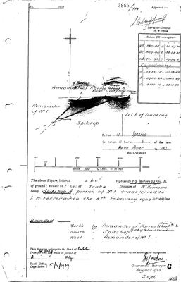 Surveyor-General diagram, 3965/1938, August 1922
10TKS201 spitskop.jpg
Research notes
[1 Aug 2026 inbox] SG Dgm 3965/1938 (DOC-0157), a portion of Portion 6 of the farm Karee Rivier No. 143, Willowmore, in the Field Cornetcy of TRAKA, which is our own ward. Surveyed AUGUST 1922, approved by the Surveyor-General 10.8.1938; the sheet also carries the number 1921. Described as 'Spitskop A, portion of No. 1, transferred to I.W. FERREIRA JR on the 8th February 1904, D/T 1408/1904'. THE REASON IT IS IN THIS MODEL: the diagram belongs to DEED OF PARTITION No. 3399, Deeds Office Cape Town, 5 APRIL 1939, made in favour of A.F. HITGE. Hitge is one of the families married into this one (Aletta Catharina Maria Helena HitgeM, PER-000139; Charles Frederik Hitge in S012), so this is Hitge ground in the Traka in 1939. Which A.F. HitgeH is not established and the initials alone will not settle it, per 9. See LEAD-0055. Bounded N by the Remainder of Karree Rivier and Lot A of a portion of Karree Rivier, S by Spitskop (Lot A), W by the Remainder of No. 1. Lot A of Vondeling is drawn adjoining, and Vondeling is also Uitnood's eastern neighbour (PAR-000100), so these two sheets overlap on the ground. THE DIAGRAM CARRIES CO-ORDINATES, in Cape Roods on the old system: a (-3436.14, -15556.42), b (-3700.26, -15802.29), c (-4100.10, -15813.40). Per 9 these are NOT converted by eye. A Cape Datum to WGS84 transform in the Karoo is a 280 to 300 m shift and needs doing properly. NO GEOMETRY. [1 Aug 2026]
[SRC-320, 7 Aug 2026] A FARM CEMETERY IS RECORDED ON THIS GROUND BY eGGSA: 'Klein Uitspanning 143, Jakhalsfontein', Cemetery ID 7477, at -33.175467, 21.624750. Photographs and captions at https://graveswcape.eggsa.org/PRINCE-ALBERT-Rural/0223007%20Grafte%20by%20Jakhalsfontein%20Klein%20Uitspanning%20_Pieter%20Olckers/ - linked, not copied.
The research behind this page, kept separate from it: dated working notes, open questions, and what is not yet settled.
Open questions
-
Which A.F. Hitge took Spitskop in 1939?
priority 3 · LEAD-0055
Who is the A.F. HitgeH named in Deed of Partition No. 3399 of 5 April 1939 over Karee Rivier No. 143 Portion 11?
What would settle it Reading Deed of Partition 3399, which names every party to it in full. The diagram recites only one of them.
What the record is missing
-
35 years, and the ground changes hands to nobody we can follow
second order · B1 succession
On Spitskop (Karee Rivier No. 143 Ptn 11), I.W. Ferreira JrH is the last owner recorded from 1904-02-08, and the next entry is A.F. HitgeH from 1939-04-05, 35 years later, with no person in common. DOC-0157 records the later arrival but not the 35 years before it.
What would settle it The Deeds Office transfer register for this farm between 1904 and 1939. A transfer names its predecessor in title, so one deed closes the whole gap.
-
The record stops in 1939 and never resumes
third order · B2 trail-ends
Spitskop (Karee Rivier No. 143 Ptn 11) was worked as far as 1939-04-05, with I.W. Ferreira JrH the last owner on record. 87 years follow with nothing. Who held it after that, and is it still one farm?
What would settle it The current title deed traced backwards, each transfer names the one before it, or the Surveyor-General's subdivision diagrams, which are what usually explain a farm going quiet.
Found by breaks.py reading the model against itself, not written by hand,
each one is a shape of missing record, not a fault in the data.
The whole set is on the
questions page.