Surveyor-General diagram, 1927/1860, November 1859
Surveyor-General diagram, November 1859
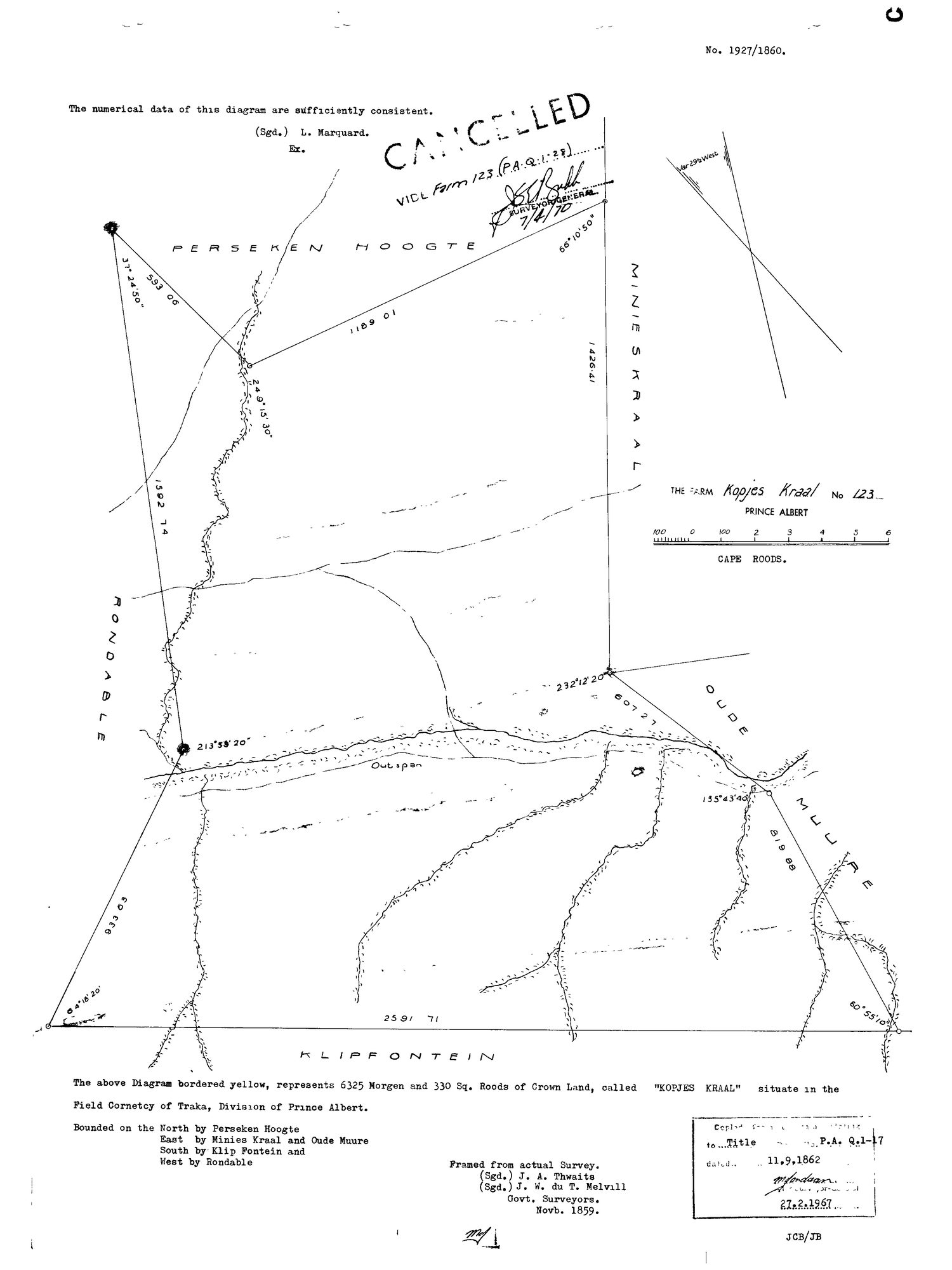
SCAN325.TIF.The record
- Type
- Surveyor-General diagram
- Diagram number
- 1927/1860
- Surveyed
- November 1859
- Titled
- 11 September 1862
- Deed
- P.A.Q.1-17
- Surveyor
- J.A. Thwaits; J.W. du T. Melvill
- Examiner
- L. Marquard
- Archive filename
- SCAN325.TIF
Citation
- Title
- Kopjes Kraal No.123 diagram (1859 survey)
- Repository
- Surveyor-General / Deeds e-portal
- Reference
- SG Dgm 1927/1860
- Type
- SG diagram
The ground it is about
Kopjes Kraal 123
Research notes
6325 morgen 330 sq roods of CROWN LAND, Field Cornetcy of Traka. Bounded N Perseken Hoogte, E Minies Kraal & Oude Muure, S Klip Fontein, W Rondable. An "Outspan" marked. CANCELLED 7-4-1970 vide Farm 123 (P.A.Q.1-28). Same surveyor (Thwaits) who resurveyed Middelwater in 1883.
[5 Aug 2026 inbox] A READABLE SCAN OF THE SAME SHEET replaced the one held. The file on disk was a 39 kB TIF - effectively a thumbnail, and nothing on it could be read. 5 MB JPEG of the same diagram, and source_file now points at that; the TIF is kept beside it as the archive master. SAME SHEET, SO NO NEW DOC- ROW, per 8. WHAT THE READABLE VERSION SHOWS AND THE THUMBNAIL DID NOT: (1) A CANCELLED STAMP across the face - 'CANCELLED. VIDE Farm 123 (P.A.Q. 1-28)', signed by the Surveyor-General 7/4/70. That is 7 April 1870, and P.A.Q. 1-28 is exactly the grondbrief recited on the 1933 Kromrivier diagram (DOC-0247) as issued 17 May 1871 'ten gunste van GEROLUM MARINCOWITZ'. So the 1860 diagram was cancelled in 1870 and replaced by the title Gerolm Marincowitz took in 1871 - which is the sequence the parcel note had flagged as [TO VERIFY why] between the 1859 survey at 6325 mg 330 sr and the 1863 resurvey at 4982 mg 370 sr. (2) The examiner's note, 'The numerical data of this diagram are sufficiently consistent. (Sgd.) L. MarquardM.' (3) The full boundary list: bounded on the NORTH by PERSEKEN HOOGTE, EAST by MINIES KRAAL and OUDE MUURE, SOUTH by KLIP FONTEIN, WEST by RONDABLE. (4) An OUTSPAN drawn on the face, south of the werf. (5) The surveyors, 'Framed from actual Survey. (Sgd.) J. A. Thwaits, (Sgd.) J. W. du T. Melvill, Govt. Surveyors, Novb. 1859', and the copy stamp to Title P.A. Q.1-17 dated 11.9.1862, re-stamped 27.2.1967.
The research behind this page, kept separate from it: dated working notes, open questions, and what is not yet settled.