Ockerts Kraal Nr. 200 (Ladismith)
200 op die kadaster · op rekord 1805–1838 · wys op die kaart
- Plaasnommer
- Nr. 200
- Ook aangeteken as
- Ockerts Kraal No. 502 (Swellendam division, 1838); de Okkers kraal gelegen aan de Groote Rivier onder de Wagendrift (1808); OKKERSKRAAL
- Op die kadaster
- 200, heel plaasgeregistreer as OKKERSKRAAL
- Grootte, soos die kaart dit stel
- 3706 morgen (1838)
- Moderne opgemete oppervlakte
- 3249.3 ha
Die historiese grootte en die moderne opgemete oppervlakte is twee aparte metings en word hier nie aangebied asof hulle mekaar bevestig nie. Die eerste is wat 'n landmeter op 'n kaart geskryf het, gewoonlik in morg. Die tweede is wat die moderne kadaster teken.
Waarom hierdie plaas hier is
Gerrit Johannes Oosthuizen het dit gehou. 133 km van Klaarstroom.
Gerrit Johannes Oosthuizen is regstreeks op hierdie grond aangeteken. Geen spoor nodig nie.
- dokument 'n Dokument in die versameling beskryf hierdie grond DOC-0347
- dokument 'n Dokument in die versameling beskryf hierdie grond DOC-0376
- leidraad 'n Oop vraag in hierdie rekord gaan oor hierdie grond Who was Ockertskraal named for, and does the name predate 1838?
- leidraad 'n Oop vraag in hierdie rekord gaan oor hierdie grond Which Platte Kloof did the clerks mean - is Pieter Cornelis's Kleine Doornrivier the Riversdale farm or the Oudtshoorn one?
- …en nog 1, volledig gelys verder af op hierdie bladsy.
Wat die rekord hou, in volgorde
-
voor 1805
ownership
Gerrit Johannes Oosthuizen (10 Februarie 1760–1825)
loan farm · occupation · confidence medium
-
23 September 1808
document
estate inventory
MOOC8/57.36a and 57.36b
-
23 September 1808
estate
Gerrit Johannes Oosthuizen (10 Februarie 1760–1825)
MOOC8/57.36a and 57.36b · the loan places Buffelskloof 'gelegen over de Plattekloof' and Okkerskraal 'aan de Groote Rivier onder de Wagendrift'
-
voor 1808-09-23
ownership
Gerrit Johannes Oosthuizen (10 Februarie 1760–1825)
loan farm · estate inventory · confidence high
- 1838 document SG diagram 641/1838
-
1 November 1838
ownership
Stephanus A. Forie
quitrent · grant · confidence high
Dokumente
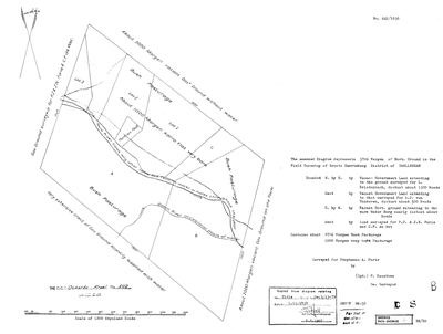 Landmeter-generaal-kaart, 641/1838, 1838
10686447.jpg
Kadaster
Die Landmeter-generaal se kaartindeks vir hierdie perseel
Navorsingsnotas
ANSWERS AN OPEN QUESTION IN 9, which records that the provincial cadastre cannot say which farm number Ockertskraal is - the question SRC-497's 1805 opgaafrol asks. SG diagram 641/1838 (DOC-0347) gives it: farm No. 502, Swellendam division, 'Field Cornetcy of Groote Swarteberg'. 3706 morgen surveyed for Stephanus A. ForieH, on the Touw and Doorn Rivers below the Warm Water Berg. Bounded East by ground surveyed for A.J. van Tonderen - a VAN TONDER on the boundary, and Susanna Catharina van TonderM is the mother of the Koup brothers. [TO VERIFY] whether the farm NAME predates the 1838 survey and whether any Ockert stands behind it; a name is not a person.
[2026-09-23, SRC-680] PINNED, AND AN OOSTHUIZEN ON IT IN 1808. MOOC8/57.36a-b: the estate of Susanna la Grange, wife of GERRIT JOHANNES OOSTHUISEN D'OUDE (PER-000239, Ockert's brother), holds 'een opstal staande op de leningsplaats gen:t de Okkers kraal gelegen aan de Groote Rivier onder de Wagendrift', taxed at Rd 150, beside his home place Buffelskloof 'over de Plattekloof' (OWN-000128). THE PIN: the Ladismith cadastre carries OKKERSKRAAL as No. 200, 3249 ha at 21.16E 33.68S, just north of the Warmwaterberg on the Touws; the 1838 diagram's 3706 morgen is 3174 ha, a 2% difference, and its 'below the Warm Water Berg' agrees. Ladismith was cut from Swellendam in 1852, which is how No. 502 of Swellendam became No. 200. WHAT DOES NOT AGREE: the 1958 face of Rietfontein A No. 139 (PAR-000291) names 'Rem of Ockerts Kraal' to its south-east, and No. 200 lies 16 km from it, too far to adjoin; either a second remainder carried the name or the 1958 sheet's neighbour is another ground. [TO VERIFY] on the two diagrams side by side. PREQUEL GROUND; NEVER core.
[23 Sep 2026, FRANS] HIS COORDINATE CONFIRMS THE PIN: 33 41 11.8 S, 21 10 00.2 E falls INSIDE Okkerskraal No. 200 (3,252 ha), one kilometre from the cadastre's own tag point for the farm. Three independent things now agree - the 1838 diagram's extent and its 'below the Warm Water Berg', the 1808 estate's description, and a point on the ground. AND THE WAGENDRIFT IS STILL THERE IN A NAME: the 1808 estate has 'de Okkers kraal gelegen aan de Groote Rivier ONDER DE WAGENDRIFT' (MOOC8/57.36a-b), and WAGENPADS No. 201 lies 3.3 km away. A wagon crossing is what both names remember. WHO THE OCKERT WAS IS STILL OPEN. It is plausible and unproven: that father died young in 1737 and nothing places him here, while the published MOOC8 carries at least three other Ockert BritsMes in this country (d'oude, de jonge and Ockertszoon, appraising estates 1785-1804), an Ockert BritsM married to an Oosthuizen in 1793, and Ockert Olivier next door. A name is not a person. WHAT WOULD SETTLE IT: the loan-farm register entry for Okkerskraal, which gives a place its first holder and year the way RLR 19 p. 94 gave Gamthous Bergh to Jacobus in 1765.
Werknotas, hier gewys omdat dit 'n private navorsingsbou is.
Die werksnotas op hierdie werf word in Engels gehou en word nie vertaal nie. Hulle verander met elke navorsingsessie, en 'n vertaling sou uit pas raak met die oorspronklike. Alles anders - die stories, die getranskribeerde dokumente en die koppelvlak - is in Afrikaans.
Oop vrae
-
Who was Ockertskraal named for, and does the name predate 1838?
prioriteit 2 · LEAD-0300
Ockerts Kraal No. 502, Swellendam, is surveyed in 1838 for Stephanus A. ForieH (DOC-0347) - a name that has nothing Ockert about it. Farm names in this district routinely outlive the household that earned them, so the question is whether 'Ockerts Kraal' was already the name of the ground when Rawstone drew it, and if so whose kraal it was.
Wat dit sou uitmaak A pre-1838 record naming Ockertskraal, with a holder.
-
Which Platte Kloof did the clerks mean - is Pieter Cornelis's Kleine Doornrivier the Riversdale farm or the Oudtshoorn one?
prioriteit 2 · LEAD-0364
MOOC8/23.3 (1800) puts Pieter Cornelis Oosthuijsen's farm at 'de Kleine Doornrivier gel: agter de Platte Kloof'; MOOC8/57.36b (1808) puts his brother Gerrit Johannes's Buffelskloof 'over de Platekloof'; MOOC8/60.16b (1814) puts J.H.C. Oosthuijzen's Eilands Valei 'agter de Platte Kloof onder het district van Zwellendam'. The cadastre has a Platte Kloof in the Langeberg above Riversdale (No. 90) and one in George (No. 131), and a Kleine Doorn Rivier behind each: Riversdale No. 1 and Oudtshoorn No. 216. Which Platte Kloof is the landmark, and so which farm was his?
Wat dit sou uitmaak A roll or register that names the Kleine Doornrivier with a district, a field cornetcy or a neighbour; or Pieter Cornelis on a George roll, which would move it. THE ROLL'S OWN DISTANCE COLUMN IS THE SHARPEST TEST: the 1808 opening at SRC-521 gives every farm in hours from the Swellendam drostdy, and the three Ladismith farms already placed (Voorbaat 14, Ockerts Kraal 15, Wolvefontein 17 uuren) calibrate it at about five kilometres to the hour. Riversdale No. 1 would read about 10 uuren; Oudtshoorn No. 216 about 33. One figure against entry 439 decides it.
-
Align and read the rest of the 1808 Landerijen leaf, image 343, rows 440-472
prioriteit 3 · LEAD-0366
The right-hand leaf of the opening that holds entries 436-472 names the farms of the Touwsberg, the Touws river, the Rooiberg and the Swartberg at 13-18 uuren, with the ward labels 'agter de Swarteberg' and 'agter de Tradouw', but on screen the rows after 439 could not be ruled against the names leaf. Which household holds which farm?
Wat dit sou uitmaak Each farm line matched to an entry number, and the column headers of the numeric block on the right-hand leaf read.
Wat die rekord kortkom
-
The record stops in 1838 and never resumes
second order · B2 trail-ends
Ockerts Kraal Nr. 200 (Ladismith) was worked as far as 1838-11-01, with Stephanus A. ForieH the last owner on record. 188 years follow with nothing. Who held it after that, and is it still one farm?
What would settle it The current title deed traced backwards, each transfer names the one before it, or the Surveyor-General's subdivision diagrams, which are what usually explain a farm going quiet.
-
30 years, and the ground changes hands to nobody we can follow
second order · B1 succession
On Ockerts Kraal Nr. 200 (Ladismith), Gerrit Johannes OosthuizenH is the last owner recorded from ../1808-09-23, and the next entry is Stephanus A. ForieH from 1838-11-01, 30 years later, with no person in common. DOC-0347 records the later arrival but not the 30 years before it.
What would settle it The Deeds Office transfer register for this farm between 1808 and 1838. A transfer names its predecessor in title, so one deed closes the whole gap.
Found by breaks.py reading the model against itself, not written by hand,
each one is a shape of missing record, not a fault in the data.
The whole set is on the
questions page.