Uitkyk Nr. 12 (Oudtshoorn)
12 op die kadaster · op rekord 1911 · wys op die kaart
- Plaasnommer
- Nr. 12
- Op die kadaster
- 12, heel plaasgeregistreer as UITKYK
- Grootte, soos die kaart dit stel
- 2495 morgen 255 square roods
- Moderne opgemete oppervlakte
- 2128.5 ha
Die historiese grootte en die moderne opgemete oppervlakte is twee aparte metings en word hier nie aangebied asof hulle mekaar bevestig nie. Die eerste is wat 'n landmeter op 'n kaart geskryf het, gewoonlik in morg. Die tweede is wat die moderne kadaster teken.
Waarom hierdie plaas hier is
Beskryf deur 'n dokument in hierdie versameling. 12 km van Klaarstroom.
- dokument 'n Dokument in die versameling beskryf hierdie grond DOC-0316
Wat die rekord hou, in volgorde
- Januarie 1911 document SG diagram 2920
Ook begrens deur, soos die moderne kadaster dit teken
Grond wat aan hierdie plaas raak op die Landmeter-generaal se huidige poligone en wat geen kaart wat hier gehou word, noem nie. Afgelei uit die meetkunde, nie van 'n dokument afgelees nie.
- N Klein Valie Nr. 182
- N Drie Punt Nr. 181
- E Witberg Nr. 180
- E Blaauwpunt Nr. 13 (Oudtshoorn)
- SW Voorzorg Nr. 24 (Oudtshoorn)
- NW Oude Kraal (Klein Valie Nr. 182 Gdlt 1)
- NW Spitzkop Nr. 10 (Oudtshoorn)
Dokumente
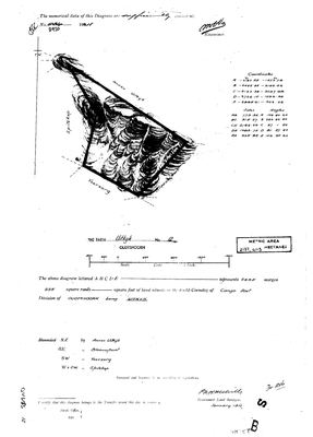 Landmeter-generaal-kaart, 2920, Januarie 1911
10068042.jpg
Kadaster
Die Landmeter-generaal se kaartindeks vir hierdie perseel
Navorsingsnotas
SG diagram of January 1911 (DOC-0316), diagram no. 2920: 2495 morgen 255 square roods, with a later metric stamp of 2137,4113 HECTARES. The two agree - 2495 morgen is 2137 ha - and the cadastre polygon draws 2129.4 ha, so the identification is confirmed on the extent before anything rests on it.
*** THE FIELD CORNETCY IS CANGO EAST. *** That is the Cango valley above Oudtshoorn, the country SG 2440 OB of 1877-79 covers (SRC-493), and it is the ground this project has been working towards on the southern Olifants.
Bounded, in the diagram's own words: N.E. by ANNEX UITKYK, S.E. by BLAAUWPUNT, S.W. by VOORZORG, W and S.W. by SPITZKOP. None of the four is in this model yet. Note that the Spitskop this project holds is a portion of Karee Rivier No. 143 in WILLOWMORE and is a different place - 5.
AND NOTE WHAT THIS FARM IS NOT: this project's farm 12 is RIETFONTEIN No. 12 in PRINCE ALBERT (PAR-000156). Farm numbers are per-division and these are unrelated farms.
No owner is named on the sheet; the transfer certificate at the foot is blank.
Werknotas, hier gewys omdat dit 'n private navorsingsbou is.
Die werksnotas op hierdie werf word in Engels gehou en word nie vertaal nie. Hulle verander met elke navorsingsessie, en 'n vertaling sou uit pas raak met die oorspronklike. Alles anders - die stories, die getranskribeerde dokumente en die koppelvlak - is in Afrikaans.
Oop vrae
-
Which cadastral polygons are Annex Uitkyk, Blaauwpunt, Voorzorg and Spitzkop?
prioriteit 2 · LEAD-0241
SG diagram 2920 of 1911 names four farms bounding Uitkyk No. 12 in the Field Cornetcy of Cango East. All four are in the model as NO-POLYGON. Which modern farms are they?
Wat dit sou uitmaak Any one of the four neighbours' own diagrams, or the 1879 regional sheet read at the Cango East.
Wat die rekord kortkom
-
Nobody is on record as ever having held this
third order · B8 never-held
Uitkyk Nr. 12 (Oudtshoorn) is in the model and drawn on the map, and carries no ownership record of any kind, not a grant, not a transfer, not an occupation.
What would settle it The Surveyor-General's diagram for the farm number names the grantee and the date; the deed reference on it opens the transfer chain.
Found by breaks.py reading the model against itself, not written by hand,
each one is a shape of missing record, not a fault in the data.
The whole set is on the
questions page.