Rietfontein Nr. 12
12 op die kadaster · op rekord 1839–1864 · wys op die kaart
- Plaasnommer
- Nr. 12
- Op die kadaster
- 12, heel plaasgeregistreer as MINNIES KRAAL
- Distrik
- Prince Albert
- Grootte, soos die kaart dit stel
- 15 167 morgen 520 square roods (1868); 13 290 morgen (1839)
- Moderne opgemete oppervlakte
- 12950.5 ha
Die historiese grootte en die moderne opgemete oppervlakte is twee aparte metings en word hier nie aangebied asof hulle mekaar bevestig nie. Die eerste is wat 'n landmeter op 'n kaart geskryf het, gewoonlik in morg. Die tweede is wat die moderne kadaster teken.
Waarom hierdie plaas hier is
'n Stuk van 'n plaas wat reeds in hierdie model is. 53 km van Klaarstroom.
- perseel Grond uit hierdie plaas gesny: Rietfontein Nr. 12 Restant
- perseel Grond uit hierdie plaas gesny: Rietfontein Nr. 12 Gdlt 1
- perseel Grond uit hierdie plaas gesny: Rietfontein Nr. 12 Gdlt 2
- grens Deel 'n grens met Spreeuw Fontein & Toornits Kraal (Spreeufontein Nr. 26) Spreeuw Fontein & Toornits Kraal (Spreeufontein Nr. 26)
- …en nog 2, volledig gelys verder af op hierdie bladsy.
Wat die rekord hou, in volgorde
-
1839
document
SG diagram 523/1839
Bf.W.Q. 5-27
-
September 1864
document
SG diagram 995/1868
P.A.Q. 1-24
- September 1864 document SG diagram verso 995/1868 (verso)
- undated boundary change subdivision: becomes Rietfontein Nr. 12 Restant
- undated boundary change subdivision: becomes Rietfontein Nr. 12 Gdlt 1
- undated boundary change subdivision: becomes Rietfontein Nr. 12 Gdlt 2
Grond uit hierdie plaas gesny
- Rietfontein Nr. 12 Restant RE/12 · 4950.6 ha
- Rietfontein Nr. 12 Gdlt 1 2490.5 ha
- Rietfontein Nr. 12 Gdlt 2 5509.4 ha
Begrens deur, soos die kaart hulle noem
- N Graf Fontein (1839)
- N/W Spreuw Kloof (1839)
- S Antjes Fontein
- SE Riet Poort
- E Government Ground (1839)
- NNE Kaffirs Kraal (1868)
- NW/S/SW Spreeuw Fontein
- NW Lammer Kraal (1868)
Ook begrens deur, soos die moderne kadaster dit teken
Grond wat aan hierdie plaas raak op die Landmeter-generaal se huidige poligone en wat geen kaart wat hier gehou word, noem nie. Afgelei uit die meetkunde, nie van 'n dokument afgelees nie.
- E Rietfontein Nr. 12 Gdlt 2
- E Rietpoort Nr. 13
- S Plaas 215
- S Waterval (Farm 215 Gdlt 1)
- W Vredendal (Spreeufontein Nr. 26 Gdlt 1)
- W Rietfontein Nr. 12 Gdlt 1
- NW Rietfontein Nr. 12 Restant
Dokumente
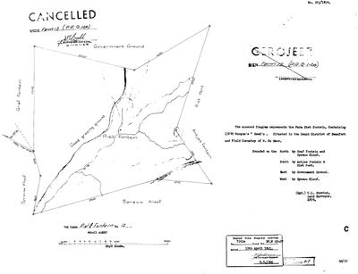 Landmeter-generaal-kaart, 523/1839, 1839
SCAN164 12 0.jpg
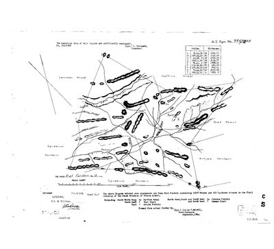 Landmeter-generaal-kaart, 995/1868, September 1864
10130403 12 0.jpg
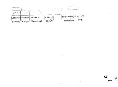 Kaart se keersy, 995/1868 (verso), September 1864
10130406 12 0.jpg
Kadaster
Die Landmeter-generaal se kaartindeks vir hierdie perseel
Navorsingsnotas
[4 Aug 2026, SRC-254/255] THE FARM NUMBER IS NOW SETTLED FROM THE FARM'S OWN DIAGRAMS. Both sheets are titled "THE FARM RIET FONTEIN No 12, PRINCE ALBERT". Since 29 July this project has carried a conflict - the Willis and Atkinson cameo maps Rietfontein as farm 12 while the downloaded cadastre names farm 12 MINNIES KRAAL - and the 1955 Minnies Kraal diagram already showed Minnies Kraal is 112. This closes it the other way round: 12 IS Rietfontein, and the cadastre extract is wrong, almost certainly 112 keyed as 12. THE 1839 SHEET (No. 523/1839, C.L. Stretch): 13 290 morgen, "situated in the GOUPH District of Beaufort and FIELD CORNETCY OF M. DE BEER", bounded north by Graf fontein and Spreuw Kloof, south by Antjes fontein and Riet Port, east by Government Ground, west by Spreuw Kloof. Titled Bf.W.Q. 5-27 on 15 April 1841 - another farm on STO-0007's day. Later CANCELLED, 2 Oct 1969. THE 1868 SHEET (No. 995/1868): 15 167 morgen 520 square roods, "in the Field Cornetcy of the GOUPH DIVISION OF PRINCE ALBERT", framed from actual survey by J.W. du T. MELVILL, Government Surveyor, September 1864, examined by L. MARQUARD, quitrent P.A.Q. 1-24 of 25 September 1868. Neighbours are now Kaffirs Kraal (NNE), Riet Poort (SE), ANTJES FONTEIN (E), SPREEUW FONTEIN (NW, S, SW) and Lammer Kraal (NW).
[4 Aug 2026] plc_id was blank, so match_cadastre.py skipped this row entirely - it matches only within a registration division and a blank plc_id yields no division. Set to PLC-000001, Prince Albert.
[4 Aug 2026] THE ANSWER IS A RENAME, NOT A KEYING ERROR IN THE CADASTRE. The cadastre holds BOTH farms as separate polygons with separate portion sets - MINNIES KRAAL 12 (12 957,1 ha, portions 1/12, 2/12, RE/12) and MINNIES KRAAL 112 (9 659,1 ha, portions 1/112 to 8/112) - and their centroids lie about 40 km apart. They are two different farms that share a name. WHAT SETTLES IT IS THE EXTENT, and it is not close: this farm's own 1868 diagram (No. 995/1868) gives 15 167 morgen 520 square roods, which at the 0,856532 factor is 12 991,0 ha. The cadastre gives farm 12 as 12 957,1 ha. THAT IS 0,26% APART - the same ground, measured 150 years apart. So RIET FONTEIN No. 12 IS THE FARM NOW REGISTERED AS MINNIES KRAAL 12. The diagrams are right that it was Riet Fontein; the cadastre is right that it is Minnies Kraal today; the farm was renamed, which warns is one of the two readings whenever our name and the cadastre's disagree. Both names are kept - the historic one in current_name because that is what the 1839 and 1868 sheets say, the modern one recorded here. IT IS NOW ON THE MAP. It never was, for a second and separate reason: plc_id was BLANK, and match_cadastre.py only matches a parcel inside its own registration division, so a blank plc_id meant the row was skipped before the farm number was even considered. [TO VERIFY]: the date and instrument of the rename.
[4 Aug 2026] NAME: the modern cadastral name is now IN the parcel name, not only in these notes. Frans could not find the farm - "i still dont see minnies kraal 12" - because it was drawn on the map all along under its historic name, Riet Fontein No. 12, and nothing joined that to the MINNIES KRAAL he was cross-checking against in the Surveyor-General's viewer. A rename recorded only in prose is a rename the reader cannot use. The parenthetical follows the pattern already used here for Klaarstroom No. 184 (Klaarstroom A) and De Claar Stroom (Klaarstroom No. 178). The historic name stays first because that is what the 1839 and 1868 diagrams say. (was: 'Riet Fontein No. 12')
[4 Aug 2026, FRANS] NAME ORDER REVERSED: "you misnamed minnies as riet fontein". The historic name had stood first because the 1839 and 1868 diagrams both read "THE FARM RIET FONTEIN No 12", and the map label takes whatever stands before the bracket, so the map printed RIET FONTEIN across ground that everyone in the district, and the Surveyor-General's own viewer, calls MINNIES KRAAL. A map should carry the name in use. The historic name is not lost: it stays in the parcel name in brackets, in the diagrams' own titles, and in the reasoning above that identified the two as one farm. This is the same split 5a already makes - the document keeps what the document says, and the label people navigate by is the name they use. (was: 'Riet Fontein No. 12 (Minnies Kraal)')
Verouderd: hieronder beantwoord [4 Aug 2026, FRANS] NAMED NEUTRALLY AS 'FARM 12', DELIBERATELY, AND THE NAME QUESTION IS PARKED. THE NAME IS GENUINELY CONTESTED and this project should not assert either side on a label. The farm's OWN DIAGRAMS, 523/1839 and 995/1868, are both titled "THE FARM RIET FONTEIN No 12, PRINCE ALBERT". The modern cadastre, and Frans, call it MINNIES KRAAL. Both are right about their own moment, and this row was named Riet Fontein, then Minnies Kraal, within the hour - which is exactly the sign that the label was carrying a judgement it should not carry. 'Farm 12' asserts only the number, which nobody disputes, and follows the pattern already used here for Farm 215, 222, 236, 237 and 241. Both names, and the evidence joining them, are in the notes above and in LEAD-0085. This is a PARKING, not a finding. [5 Aug 2026, LEAD-0085] A NAMED SIGHTING: the Farm 215 consolidation sheet of 1990 (DOC-0238, L.G. 7373-90) labels this farm RIETFONTEIN twice on its neighbour ring - 'Gedeelte 1 van Rietfontein Nr 12' and 'Restant van Rietfontein Nr 12'. So the Surveyor-General was still writing Rietfontein for farm 12 in 1990, which bears on when, and whether, the name changed to Minnies Kraal.
[8 Aug 2026, from SG 523/1839 read for the first time] THE FARM'S NAME IS RIET FONTEIN, and this project has been calling it 'Farm 12'. Stretch's 1839 sheet is headed 'the FARM RIET FONTEIN, Containing 13290 Morgen's, Situated in the GOUPH DISTRICT OF BEAUFORT and FIELD CORNETCY OF M. DE BEER'. Bounded N Graf fontein and Spreeuw Kloof, S Antjes fontein and Riet Port, E Government Ground, W Spreeuw Kloof. The surveyor wrote GOOD GRAZING GROUND across the middle of it, along the watercourse - a judgement about the land in his own hand. Titled 15 APRIL 1841 under Bf.W Q5-27, so this is a fourth farm on the grant day. Cancelled 2 Oct 1969 vide Farm 12 (P.A.Q.1-24). A THIRD RIETFONTEIN: this project already holds two others, PAR-000010 and PAR-000052, and 9 is why none of the three is assumed to be another. [TO VERIFY] whether current_name should become Rietfontein No. 12 - the cadastre calls it Farm 12 and the 1839 diagram calls it Riet Fontein.
[8 Aug 2026, DOC-0219] ALL THREE PIECES OF THIS FARM NOW RECONCILE TO ITS OWN GRANT. The deduction table gives Portion 1 as 2,891.9588 MORGEN (survey record E.1366/58, diagram 5774/1958, transfer 7577 of 25 June 1959) and Portion 2 as 5,510,911 HECTARES (E.2758/94, diagram 8388/94, transfer 92 991/94) - two rows, two units, because metrication fell between them. Converted: 2,477.1 ha and 5,510.9 ha against the cadastre's 2,490.5 and 5,509.4, and a Remainder by subtraction of 5,003.8 against 4,950.6. The worst of the three is 1.07% out. The 1868 grant of 15,167 morgen 520 roods and the modern polygons are the same ground.
[8 Aug 2026] AND IT DATES THE PORTION LABELS ON THE FACE. DOC-0218 has "Portion 1" and "Portion 2" written across the map; the verso puts those at 1958 and 1994. The face we hold is a 1958-era copy of an 1868 sheet carrying later work, which is worth knowing before anything on it is read as contemporary.
[10 Aug 2026] RENAMED FROM MINNIES KRAAL TO RIETFONTEIN, ON THE FARM'S OWN DIAGRAMS. Two Surveyor-General sheets title farm 12 Rietfontein and neither calls it Minnies Kraal: SG 5774/58 of May 1958 [SRC-350], 'Gedeelte 1 van die plaas RIETFONTEIN Nr 12', and SG 8388/1994 [SRC-352/353], 'PORTION 2 OF THE FARM RIETFONTEIN NO. 12'. Thirty-six years apart, two surveyors, one name. THE CADASTRE CALLS FARM 12 'MINNIES KRAAL' AND ALSO CALLS FARM 112 'MINNIES KRAAL', which is where this model took the wrong name from - see LEAD-0147. This closes LEAD-0085, which asked exactly this question. This row read 'Farm 12' until today. The cadastre's placeholder name 'Farm 12' is gone with it, which was the last row under the check 'A parcel named Farm No. N that the cadastre has a name for'.
Werknotas, hier gewys omdat dit 'n private navorsingsbou is.
Die werksnotas op hierdie werf word in Engels gehou en word nie vertaal nie. Hulle verander met elke navorsingsessie, en 'n vertaling sou uit pas raak met die oorspronklike. Alles anders - die stories, die getranskribeerde dokumente en die koppelvlak - is in Afrikaans.
Oop vrae
-
Why 15 April 1841? The project's headline question has never been a lead
prioriteit 1 · LEAD-0091
Was the day a batch signature clearing a quitrent conversion backlog, a settlement scheme, or routine administration?
Wat dit sou uitmaak The register. If many farms across the district share the date and the underlying entries are spread over years, it is a signing session and the question is answered.
-
Three farms carry the same name twice or three times, and ten story links are held back because of it
prioriteit 2 · LEAD-0080
Which Rietfontein, which De Claar Stroom, and is Sleutelfontein (Groot and Klein) a real parcel or a composite of two?
Wat dit sou uitmaak For each mention, which parcel the sentence means. For Sleutelfontein, whether PAR-000098 should exist at all given PAR-000071/072.
-
The cadastre gives the name MINNIES KRAAL to two different farms, 12 and 112
prioriteit 2 · LEAD-0147
The Surveyor-General's own diagrams call farm 12 Rietfontein and farm 112 Minnies Kraal. The modern cadastre calls BOTH of them MINNIES KRAAL, on 12,957 ha and 9,659 ha respectively. Which is the error, and when did farm 12 stop being Rietfontein in the register?
Wat dit sou uitmaak A deeds or SG record naming farm 12 after 1994.
-
What should farm 12 be called on this site - Riet Fontein or Minnies Kraal?
prioriteit 3 · LEAD-0085
The farm's own 1839 and 1868 diagrams title it RIET FONTEIN No 12; the modern cadastre and local usage call it MINNIES KRAAL. Which name should the map and the pages carry?
Wat dit sou uitmaak A dated document carrying the name Minnies Kraal for farm 12, or a deed recording the change.
Wat die rekord kortkom
-
Nobody is on record as ever having held this
third order · B8 never-held
Rietfontein Nr. 12 is in the model and drawn on the map, and carries no ownership record of any kind, not a grant, not a transfer, not an occupation.
What would settle it The Surveyor-General's diagram for the farm number names the grantee and the date; the deed reference on it opens the transfer chain.
Found by breaks.py reading the model against itself, not written by hand,
each one is a shape of missing record, not a fault in the data.
The whole set is on the
questions page.