Landmeter-generaal-kaart, 995/1868, September 1864
Landmeter-generaal-kaart, September 1864
10130403 12 0.jpg.Die rekord
- Soort
- Landmeter-generaal-kaart
- Kaartnommer
- 995/1868
- Opgemeet
- September 1864
- Getitel
- 25 September 1868
- Akte
- P.A.Q. 1-24
- Landmeter
- J.W. du T. Melvill
- Eksaminator
- L. Marquard
- Argieflêernaam
- 10130403 12 0.jpg
Sitasie
- Titel
- SG Dgm 995/1868 - the farm Riet Fontein No. 12, Prince Albert, resurveyed
- Bewaarplek
- Landmeter-Generaal, Kaapstad
- Verwysing
- No. 995/1868; framed from actual survey by J.W. du T. Melvill, Govt Surveyor, September 1864; examined by L. Marquard; quitrent P.A.Q. 1-24, Sheet CL-7, 25 September 1868, J.J. de Villiers; copy 1149/1958
- Soort
- SG diagram
- Afgehaal
- 2026-08-04
Die grond waaroor dit gaan
Navorsingsnotas
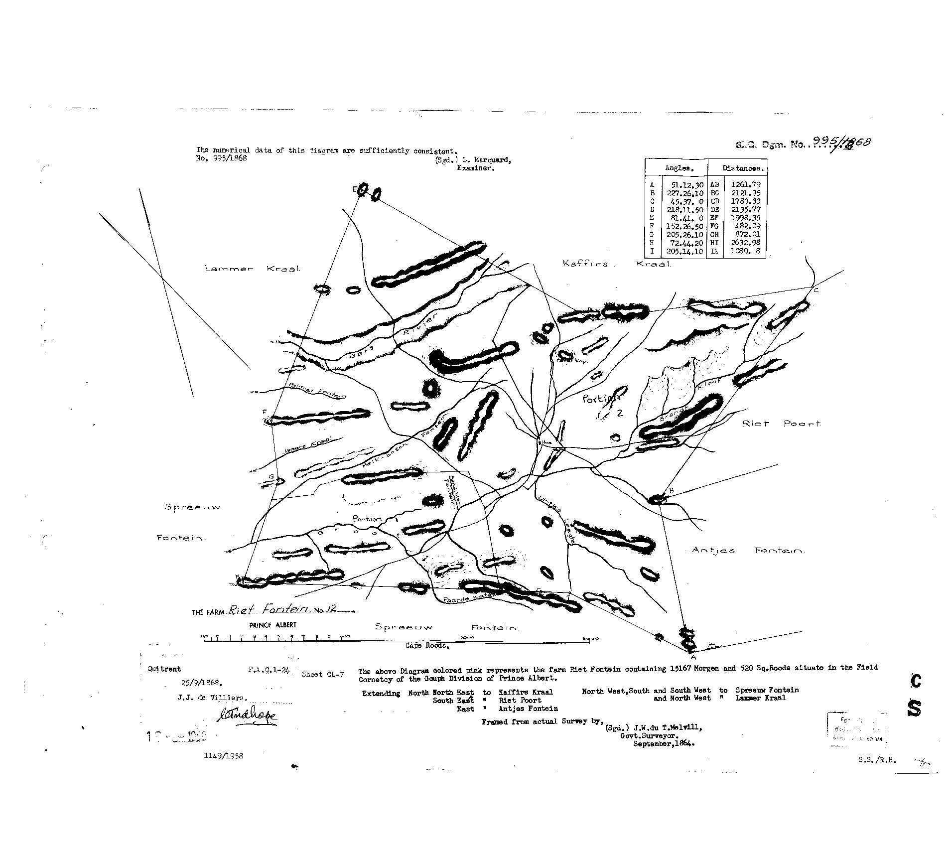
[8 Aug 2026] FACE READ. "S.G. Dgm. No. 995/1868. The numerical data of this diagram are sufficiently consistent. No. 995/1868. (Sgd.) L. MarquardM, Examiner." Title block: "THE FARM Riet Fontein No. 12, PRINCE ALBERT". Caption verbatim: "The above Diagram colored pink represents the farm Riet Fontein containing 15167 Morgen and 520 Sq. Roods situate in the Field Cornetcy of the Gouph Division of Prince Albert." Extending North North East to Kaffirs Kraal; South East to Riet Poort; East to Antjes Fontein; North West, South and South West to Spreeuw Fontein; and North West to Lammer Kraal. "Framed from actual Survey by, (Sgd.) J.W. du T. MelvillM, Govt. Surveyor. September, 1864." Quitrent P.A.Q.1-24, 25/9/1868, J.J. de Villiers. Sheet CL-7. Nine beacons A to I with angles and distances tabled. Scale in Cape roods. "1149/1958" pencilled at the foot.
[8 Aug 2026] THE FARM'S OWN PLACE NAMES, which are on no other sheet here: GATS RIVER across the north, PALMIET FONTEIN, JAGERS KRAAL, PAARDE WATER, and several more the scan will not resolve cleanly, so they are not transcribed rather than guessed at. [TO VERIFY] from a better copy.
[8 Aug 2026] THE GATS RIVER MAY BE WHERE GATSPLAAS GOT ITS NAME. This farm's western and southern neighbour is SPREEUW FONTEIN, PAR-000005 - the farm the district called GATSPLAAS, and the ground Vredendal stands on (STO-0033). Until now the only thing tying that local name to this ground was one line in Johanna Botma's 1939 death notice saying she was buried at Gatsplaas. Here is a watercourse called Gats drawn on the neighbouring farm's own 1868 diagram, running towards their shared boundary. A farm named off the river beside it is the ordinary way these names work. NOT PROVEN - "gat" is a common enough element, and the sheet does not carry the name Gatsplaas. [TO VERIFY] whether the Gats River crosses Spreeufontein itself on its own diagram.
[8 Aug 2026] "Portion 1" and "Portion 2" are written on the map, and they CANNOT be contemporary with it - the verso dates those portions to 1958 and 1994. The copy we hold is a 1958-era print of an 1868 sheet with ninety years of later work drawn onto it. An old sheet carrying much newer ink, like DOC-0039 (1990) and DOC-0190 (2014). Worth knowing before anything drawn on this face is read as contemporary with 1868.
Die navorsing agter hierdie bladsy, apart gehou daarvan: gedateerde werksnotas, oop vrae, en wat nog nie uitgemaak is nie.
Die werksnotas op hierdie werf word in Engels gehou en word nie vertaal nie. Hulle verander met elke navorsingsessie, en 'n vertaling sou uit pas raak met die oorspronklike. Alles anders - die stories, die getranskribeerde dokumente en die koppelvlak - is in Afrikaans.