Biesies (Bissies en Anteel Kolk Nr. 91)
· op rekord 1870–1890 · wys op die kaart
- Plaasnommer
- Nr. 91
- Ook aangeteken as
- BiesiesFAMILY, the form Frans usesBiesesas first givenBissies en Anteel Kolkthe cadastre's own form, CSG PRCL_KEY N066C026000000000091000000
- Distrik
- Fraserburg (division)
- Grootte, soos die kaart dit stel
- 11075 morgen 410 square roods
- Moderne opgemete oppervlakte
- 9515.6 ha
Die historiese grootte en die moderne opgemete oppervlakte is twee aparte metings en word hier nie aangebied asof hulle mekaar bevestig nie. Die eerste is wat 'n landmeter op 'n kaart geskryf het, gewoonlik in morg. Die tweede is wat die moderne kadaster teken.
Waarom hierdie plaas hier is
J. J. Marais (Bissies en Anteel Kolk, 1890) het dit gehou, en geen verwantskap met die Oosthuizen, Marincowitz of Van der Merwe-lyne is aangeteken nie. Hierdie grond het deur die grond ingekom, nie deur die familie nie. 305 km van Klaarstroom.
- storie 'n Geskrewe geskiedenis speel op hierdie grond af The van der Merwes of the Hantam
- dokument 'n Dokument in die versameling beskryf hierdie grond DOC-0355
- dokument 'n Dokument in die versameling beskryf hierdie grond DOC-0356
- leidraad 'n Oop vraag in hierdie rekord gaan oor hierdie grond Was Biesies Kola's farm, and when did he hold it?
Stories
- set here
Die van der Merwes van die Hantam
Van Frans se vier grootouerlyne was die van der Merwes die laaste om die Prins Albert-distrik te bereik, en hulle het van die verste af gekom. Agt geslagte van 'n doop op die Paarl in 1735 tot Vredendal omstreeks 1950, met 'n opmeting van 1823 wat die trekker self by die naam noem.
Wat die rekord hou, in volgorde
-
Junie 1870
document
SG diagram B 459/1870
Fr.Q.11-3
- 1870 document SG diagram SG 877/1870
-
27 Junie 1890
ownership
J. J. Marais (Bissies en Anteel Kolk, 1890)
freehold · transfer
Dokumente
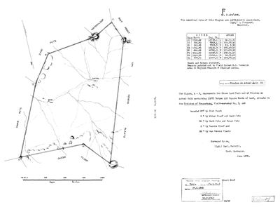 Landmeter-generaal-kaart, B 459/1870, Junie 1870
10034222 91 fraserburg bissies.jpg
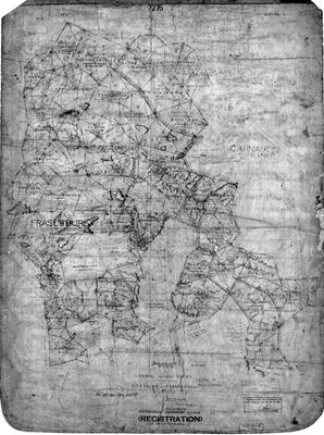 Landmeter-generaal-kaart, SG 877/1870, 1870
10136998 91 district.jpg
Navorsingsnotas
Verouderd: hieronder beantwoord [14 Aug 2026, FAMILY] THE FARM FRANS JACOBUS WILHELMUS VAN DER MERWE (PER-000030) CAME FROM - Frans's mother's father. Held as a PLACE row since(PLC-000036) and given a parcel row here on 14 Aug, because it is a farm and belongs in the farm list beside the others, not only as a dot on the map. NO POLYGON, AND THERE WILL NOT BE ONE: no farm is registered as Biesies anywhere in South Africa. The Chief Surveyor-General's own property index, searched on BIES across every division, returns Biesiewater, Biesiebult, Biesjeskuil and eighty more, and no Biesies. It is a farm the family names and the register does not - the same standing as Drooge Kloof and Vischat under 5's second rule. INDEPENDENTLY ATTESTED THREE TIMES ALL THE SAME: Janet Melville's report puts a brother of PER-000030 as 'boer op Biesies, 'n plaas in Williston distrik op die grens van Boesmanland' [SRC-374]; the IEC's Northern Cape voting station list for 20 April 2011 carries a permanent station BIESIES FARM at Williston, voting district 66020059 [SRC-375]; and John Irish's 1996 Karoo Lepismatidae survey lists collecting locality 384 as Biesies, two entries from Daskop which he places in the Williston district [SRC-376]. THE COORDINATE IS THE NORTHERN OF TWO CANDIDATES 85 km APART, written on Frans's own decision that the farm lies north-east of Williston towards Boesmanland - where Melville and Irish independently point. It is [FAMILY] and not a survey. LEAD-0156 holds the last check, Irish's numbered gazetteer.
Verouderd: hieronder beantwoord *** [14 Aug 2026, FRANS - THE PIN COMES OFF.] *** "ok, so that just means we dont know where the biesies farm was or is... lets not add landmarks we dont know." He is reversing his own 13 Aug decision, and reversing it the right way: that decision picked the northern of two candidates 85 km apart on the reasoning that the farm lies north-east of Williston towards Boesmanland, which is an argument about DIRECTION and not a location. 5 fails closed for exactly this - an unresolved place gets no map pin, because a wrong pin is worse than a missing one and a map makes a claim look authoritative. THE FARM STAYS, the coordinate goes. What is known is unchanged and is a good deal: three independent records name it, in the Williston district, on the edge of Boesmanland. Where it stands is not among them. LEAD-0156.
*** [6 Sep 2026] THE PIN GOES BACK ON, THIS TIME FROM A COORDINATE AND NOT A DIRECTION. *** [FAMILY] 30 51.27.3"S 21 08'04.7"E'. Decimal: -30.857583, 21.134639. This is 2.9 km from LEAD-0156's predicted point (30.86073 S, 21.10474 E, itself built from three independent convergences: Irish's Daskop locality 18 km away in the same 1996 collecting run, Melville's 'north-east of Williston towards Bushmanland', and Frans's own 'close to Brandvlei'). It sits 57.3 km from Williston town at a bearing of 020 degrees, which is north-north-east - agreeing with Melville's description rather than merely permitted by it. THE 14 AUGUST DECISION TO PULL THE PIN WAS RIGHT AT THE TIME: a direction is not a location, and 5 fails closed exactly so a plausible guess does not read as a survey. What changed is the KIND of evidence, not the confidence in the old one. This is Frans naming the point itself, degrees-minutes-seconds, the form a reading off a map or a device takes and not the form a hunch takes. STILL [FAMILY], AND STILL NO POLYGON: no farm is registered as Biesies anywhere in South Africa (checked 14 Aug across the Chief Surveyor-General's index). The coordinate is a point, not a boundary, and the farm's extent is not known. LEAD-0156 closed on this coordinate.
*** [6 Sep 2026] WHOSE LAND IT WAS, CORRECTED BEFORE IT WAS EVER WRITTEN WRONG. FRANS: 'careful - this is where frans grew up, but it was his father's land. he owned Vredendal.' *** THE MODEL HAD NEVER CLAIMED OTHERWISE - the existing note says only that PER-000030 CAME FROM Biesies, which is upbringing and not title, and PAR-000020 Vredendal already carries his occupation from the 195Xs to 1968 (OWN-000014). The caution is recorded because it is the right instinct and because the record can now say the positive half it was missing: Biesies is very likely the ground of PER-000219, JACOBUS JOHANNES GIDEON VAN DER MERWE, 'KOLA' (1888-1961), Frans's great-grandfather and PER-000030's own father. NOT SETTLED: Kola's 1917 marriage record gives his residence as KAREEKOP, not Biesies (SRC-374), so if Biesies is his it was acquired or occupied later, sometime between 1917 and his son's boyhood in the 1930s. No ownership row exists for either man on this farm and none is written here without one. [FAMILY, TO VERIFY]
*** [6 Sep 2026] CONFIRMED BY FRANS: 'yes, it was kola's ground.' *** Biesies is PER-000219's own farm - Jacobus Johannes Gideon van der MerweL, 'Kola' (1888-1961) - and PER-000030 grew up there as a child on his father's land before going on to hold Vredendal himself. This is now [FAMILY], stated directly, not inferred from the coordinate or the generation gap. What remains open is WHEN Kola came to be there, since his 1917 marriage record gives Kareekop - that is what LEAD-0341 still asks.
*** [6 Sep 2026] THE FARM IS IDENTIFIED: BISSIES EN ANTEEL KOLK No. 91, registration division FRASERBURG, Northern Cape. *** A point query on the national CSG cadastre (csggis.dlrrd.gov.za) at Frans's coordinate returned exactly one farm and one portion, both the same ground: PRCL_KEY N066C026000000000091000000 (farm) / ...091000001 (RE, the undivided remainder), TAG_VALUE 'BISSIES EN ANTEEL KOLK No. 91', GEOM_AREA 95,156,076 sq m (9,515.6 ha). The cadastre's own label point (TAG_X/TAG_Y) sits 1.09 km from Frans's coordinate - the two are the same farm read two ways, a phone GPS against a surveyor's label. *** BISSIES IS BIESIES. *** 5a note 6: spelling drift is evidence, not noise, and this is the family's own name in the cadastre's own hand - 'Bissies' against 'Biesies' [FAMILY] and 'Bieses' [as first given]. All three are now recorded as variants. *** AND THE REGISTRATION DIVISION IS FRASERBURG, NOT WILLISTON, WHICH IS A DIVISION/DISTRICT TRAP LIKE THE ONES 5 ALREADY WARNS OF. *** Every source this project holds - Melville, the IEC list, Irish's survey, Frans's own words - calls it a farm in the 'Williston district'. The registered ground is 56.5 km from Williston town and 122 km from Fraserburg town, so the family's usage is not wrong, it is a magisterial-district or colloquial description, and the REGISTRATION division (a Deeds Office administrative unit) is a different, narrower thing that does not have to agree with it. Both are recorded and neither is corrected out. This is also why '--csg=Williston' returned nothing at first: Williston is not a Deeds Office registration division at all. The whole Fraserburg division was pulled (447 farms, 1,004 portions) into geo/fraserburg_farms.geojson and geo/fraserburg_farm_portions.geojson, and PAR-000272 is pinned to the farm-level key (sg_farm_key) rather than left to automatic farm-number matching, because this project holds no other Fraserburg-division parcel and the automatic matcher's RD_FOR_PLC table has no entry to route it through. NO-POLYGON is withdrawn: there IS a farm registered as Biesies (as Bissies), and the 14 August finding that searched only the Chief Surveyor-General's PROVINCIAL index was searching the wrong service for a Northern Cape farm, the same class of error §9a's Calvinia paragraph already describes.
[SRC-628, 6 Sep 2026] TRANSFEREE OF BISSIES EN ANTEEL KOLK No. 91, FRASERBURG DIVISION, 27 JUNE 1890. The district registration plan (SG 877/1870) annotates the farm, against its number '91-', with 'J.J. Marais / 27 June 1890 / af.82' - the transfer that the farm's own diagram (SRC-627) also cites, as Title Deed No. Fr.Q.11-3 dated 27.6.1890. Both documents name the same transaction from two directions: the diagram cites the deed number and date, the district plan names the man. 'af.82' is not expanded here [TO VERIFY] - possibly a folio or volume reference in the deeds register. *** NOT THE SAME MAN AS PER-001714. *** This model already holds a 'Jacobus Johannes MaraisM', but as a witness at a BEAUFORT WEST baptism in 1839, fifty-one years earlier and a different district. 9: never match on a name alone. Nothing here ties the two, and they are kept as separate rows unless a document joins them. *** HOW THE GROUND REACHED KOLA'S HOUSEHOLD IS STILL OPEN. *** Kola (PER-000219) is where this family's ground on Biesies is attested [FAMILY], and his own 1917 marriage record gives his residence as Kareekop, not Biesies. Whatever chain of transfers runs from J.J. Marais in 1890 to Kola sometime before his son's 1920s-30s boyhood is not yet documented. LEAD-0341.
*** [6 Sep 2026] RE-FILED FROM THE CALVINIA DIVISION TO FRASERBURG (PLC-000060 to PLC-000097), AND THE CADASTRE KEY IS WHAT CAUGHT IT. *** This parcel was created on 14 August beside the twelve van der Merwe farms and inherited their division without anybody checking, because at that point it had no key to check against. It has one now: every Calvinia parcel here begins N065C015 and this one begins N066C026. Calvinia was a reasonable place to file a farm that was only known to be 'somewhere north-east of Williston'; it is not where the deeds office keeps it. The Williston description in every source stands and is not corrected: see PLC-000097 for why a magisterial district and a registration division are allowed to disagree.
Werknotas, hier gewys omdat dit 'n private navorsingsbou is.
Die werksnotas op hierdie werf word in Engels gehou en word nie vertaal nie. Hulle verander met elke navorsingsessie, en 'n vertaling sou uit pas raak met die oorspronklike. Alles anders - die stories, die getranskribeerde dokumente en die koppelvlak - is in Afrikaans.
Oop vrae
-
Was Biesies Kola's farm, and when did he hold it?
prioriteit P3 · LEAD-0341
[FAMILY] Biesies is where his grandfather Frans van der Merwe (PER-000030) grew up, but it was PER-000030's FATHER'S land - Jacobus Johannes Gideon van der MerweL, 'Kola' (PER-000219, 1888-1961) - and PER-000030 himself went on to own Vredendal.. Kola's own 1917 marriage record gives his residence as KAREEKOP, not Biesies. When and how did Biesies become his ground?
Wat dit sou uitmaak A document naming Kola at Biesies, or an ownership/occupation record.
Wat die rekord kortkom
-
The record stops in 1890 and never resumes
second order · B2 trail-ends
Biesies (Bissies en Anteel Kolk Nr. 91) was worked as far as 1890-06-27, with J. J. MaraisH (Bissies en Anteel Kolk, 1890) the last owner on record. 136 years follow with nothing. Who held it after that, and is it still one farm?
What would settle it The current title deed traced backwards, each transfer names the one before it, or the Surveyor-General's subdivision diagrams, which are what usually explain a farm going quiet.
Found by breaks.py reading the model against itself, not written by hand,
each one is a shape of missing record, not a fault in the data.
The whole set is on the
questions page.