Tygerhoek Nr. 689
· op rekord 1782–1823 · wys op die kaart
- Plaasnommer
- Nr. 689
- Ook aangeteken as
- Tierhoek; De Tijgerhoek; Tyger Hoek; Clw. Q1.41
- Distrik
- Calvinia (division)
- Grootte, soos die kaart dit stel
- 4446 morgen 399 sq roods
- Moderne opgemete oppervlakte
- 4033.2 ha
Die historiese grootte en die moderne opgemete oppervlakte is twee aparte metings en word hier nie aangebied asof hulle mekaar bevestig nie. Die eerste is wat 'n landmeter op 'n kaart geskryf het, gewoonlik in morg. Die tweede is wat die moderne kadaster teken.
Waarom hierdie plaas hier is
Wed. William Petrus Burger het dit gehou, en geen verwantskap met die Oosthuizen, Marincowitz of Van der Merwe-lyne is aangeteken nie. Hierdie grond het deur die grond ingekom, nie deur die familie nie. 339 km van Klaarstroom.
- storie 'n Geskrewe geskiedenis speel op hierdie grond af The van der Merwes of the Hantam
- grens Deel 'n grens met Tyger Hoek Extension Nr. 688 Tyger Hoek Extension Nr. 688
- dokument 'n Dokument in die versameling beskryf hierdie grond DOC-0269
- leidraad 'n Oop vraag in hierdie rekord gaan oor hierdie grond Who were the Tygerhoek van der Merwes, and how do Francois Johannes and the widow Burger connect to the line?
- …en nog 2, volledig gelys verder af op hierdie bladsy.
Stories
- set here
Die van der Merwes van die Hantam
Van Frans se vier grootouerlyne was die van der Merwes die laaste om die Prins Albert-distrik te bereik, en hulle het van die verste af gekom. Agt geslagte van 'n doop op die Paarl in 1735 tot Vredendal omstreeks 1950, met 'n opmeting van 1823 wat die trekker self by die naam noem.
Wat die rekord hou, in volgorde
-
24 September 1782
estate
estate inventory: Schalk Willem Burger, landbouwer, and his widow Hester Smith
MOOC8/49.25a · de Tijgerhoek, aan de Hantam (one of five opstallen)
- 15 Mei 1823 document SG diagram 128/1823
-
15 Mei 1823
ownership
Wed. William Petrus Burger
erfpacht · survey · confidence high
Begrens deur, soos die kaart hulle noem
- N Hantamsberg
- N Tygerhoeksberg
- S Gouvernements grond voor Johs van Zyl Sr. in erfpacht
- S Oorlogskloofs Rivier
- E Gouvernements grond voor J.A. van Wyk Sr. in erfpacht
- W Uitgestrektheid Gouvernements grond
Ook begrens deur, soos die moderne kadaster dit teken
Grond wat aan hierdie plaas raak op die Landmeter-generaal se huidige poligone en wat geen kaart wat hier gehou word, noem nie. Afgelei uit die meetkunde, nie van 'n dokument afgelees nie.
Dokumente
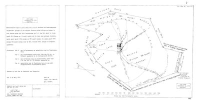 Landmeter-generaal-kaart, 128/1823, 15 Mei 1823
10018592 689 0.jpg
Navorsingsnotas
[10 Aug 2026, SRC-359/DOC-0269] THE VAN DER MERWE GROUND, and the reason this project now has a second district. A LEENINGSPLAATS measured 15 May 1823 by J.M. Wentzel on the order of the Commissie van Inspectie: 2614 morgen 19 roods of its own ground plus 1832 morgen 380 roods of adjoining government land, 4446 morgen 399 roods in all, held in erfpacht by the widow of William Petrus Burger. Izaak Johannes van der MerweM (PER-001658) was born here about 1808 and Jacobus Adriaan (PER-001631) on 30 October 1813, so Carel Aaron van der MerweL's household was on this ground fifteen years before it was surveyed. Whether they held it, rented it or worked it is not established. [TO VERIFY] NO POLYGON: this project holds no cadastral geometry for the Calvinia division, so the farm has no map pin. That is a missing dataset and not a missing place.
[10 Aug 2026] PINNED. The Calvinia division is not in the Western Cape warehouse, so it was pulled from the NATIONAL Chief Surveyor-General portal instead - fetch_cadastre.py --csg=CALVINIA. The cadastre names it exactly as the diagram does, and the extents agree: Tyger Hoek Extension is 430.9 ha against the 1879 survey's 510 morgen 532 roods, which is 437.6 ha, a difference of 1.5%. Tygerhoek is 4,033.2 ha against the 1823 figure of 4,446 morgen 399 roods, 3,808.7 ha, a difference of 5.9% across two centuries and a resurvey. The identification does not rest on the name.
[27 Sep 2026, SRC-692] THE GROUND HAS 74 YEARS OF RECORDED HISTORY BEFORE THE 1823 SURVEY, and none of it is van der Merwe. Grazing on De Tygerhoek was licensed to Nicolaas Rudolph Ryk on 27 September 1749 'on the other side of the Eliphants and Doorn River' (RLR 12/2 p.247), renewed 1755 and given up in 1760; then Hendrik Korff (RLR 16 p.8) to his death in 1765; Gerrit Munnik from 8 January 1766 (RLR 19/1 p.168); Schalk Willem Burger in 1776 (RLR 24 p.97); Albert Hendrik van Zyl in 1777 (RLR 25 p.92). Pretorius judges that Ryk, Korff and Munnik never lived here and only grazed. AND IT ANSWERS THIS ROW'S OWN OPEN QUESTION, as far as a secondary source can: Carel Aaron van der MerweL took up residence towards the end of the 1700s, but Willem Petrus Burger senior ACQUIRED the farm about 1820 - so the household was here without holding it, which is what the births of 1808 and 1813 already suggested. Willem Petrus Burger junior took the perpetual quitrent on 30 November 1837, 4446 morgen. The farm returned to the family in two halves, 31 October 1882 and 10 October 1887, both to Francois Johannes van der MerweM, 'Fransie Brandwag' (1841-1915), WHO IS BURIED ON IT. On 19 January 1847 the Colony's 33rd Dutch Reformed parish was constituted in the voorhuis here and named Hantam; the village laid out that year on Hoogekraal became Calvinia in 1851. The article is secondary and its RLR and deed references have not themselves been seen here. [TO VERIFY]
Werknotas, hier gewys omdat dit 'n private navorsingsbou is.
Die werksnotas op hierdie werf word in Engels gehou en word nie vertaal nie. Hulle verander met elke navorsingsessie, en 'n vertaling sou uit pas raak met die oorspronklike. Alles anders - die stories, die getranskribeerde dokumente en die koppelvlak - is in Afrikaans.
Oop vrae
-
Who were the Tygerhoek van der Merwes, and how do Francois Johannes and the widow Burger connect to the line?
prioriteit 1 · LEAD-0149
Carel Aaron van der MerweL's household was on Tygerhoek by 1808. The 1823 survey names the holder as the widow of William Petrus Burger, and the 1885 quitrent for the adjoining Tyger Hoek Extension goes to Francois Johannes van der MerweM. How do those two connect to the direct line?
Wat dit sou uitmaak A marriage or baptism linking the widow Burger to the van der Merwes, and a parentage for Francois Johannes.
-
Fransie Brandwag's grave on Tierhoek
prioriteit 2 · LEAD-0368
Where exactly on Tygerhoek No. 689 is Francois Johannes van der MerweM (1841-1915) buried, and is the grave recorded or photographed?
Wat dit sou uitmaak A photograph or transcription of the headstone, with a coordinate.
-
The Hantam ground has no basemap under it
prioriteit 3 · LEAD-0167
The Calvinia farms are on the map as polygons but sit over blank canvas, and the four Northern Cape cemeteries have no pins at all. What is missing, and is it worth fetching?
Wat dit sou uitmaak A re-cut basemap covering the Hantam, and a sourced coordinate for each town cemetery.
-
Lichtenstein's November 1803 call on a van der Merwe at Tyger-point
prioriteit 3 · LEAD-0369
Is the colonist Lichtenstein met in November 1803 at 'Tyger-point' Carel Aaron van der MerweL, and is the house he describes on Tygerhoek No. 689?
Wat dit sou uitmaak A passage naming the colonist, or a dated record putting Carel Aaron on the farm in 1803.
Wat die rekord kortkom
-
“Gouvernements grond voor J.A. van Wyk Sr. in erfpacht” held ground next door and we have no tenure for them
first order · B4 unheld-owner
A boundary description for Tygerhoek Nr. 689 names Gouvernements grond voor J.A. van Wyk Sr. in erfpacht, a surveyor stating on the record that this person held the adjoining ground. No one of that surname holds a single ownership span anywhere in this model.
What would settle it The diagram's own date fixes the window. The quitrent or erfpacht register for that year names the holder of the adjoining place, and an estate inventory will name the farm outright.
-
The record stops in 1823 and never resumes
second order · B2 trail-ends
Tygerhoek Nr. 689 was worked as far as 1823-05-15, with Wed. William Petrus BurgerH the last owner on record. 203 years follow with nothing. Who held it after that, and is it still one farm?
What would settle it The current title deed traced backwards, each transfer names the one before it, or the Surveyor-General's subdivision diagrams, which are what usually explain a farm going quiet.
Found by breaks.py reading the model against itself, not written by hand,
each one is a shape of missing record, not a fault in the data.
The whole set is on the
questions page.