Jan Willems Fontein Nr. 32
32 op die kadaster · op rekord 1834 · wys op die kaart
- Plaasnommer
- Nr. 32
- Op die kadaster
- 32, heel plaasgeregistreer as JAN WILLEMS FONTEIN
- Distrik
- Prince Albert
- Grootte, soos die kaart dit stel
- 7059 morgen
- Moderne opgemete oppervlakte
- 7697.9 ha
Die historiese grootte en die moderne opgemete oppervlakte is twee aparte metings en word hier nie aangebied asof hulle mekaar bevestig nie. Die eerste is wat 'n landmeter op 'n kaart geskryf het, gewoonlik in morg. Die tweede is wat die moderne kadaster teken.
Waarom hierdie plaas hier is
Hier omdat 'n oop vraag in hierdie rekord daaroor gaan; wie hierdie grond gehou het, is nog nie vasgestel nie. 72 km van Klaarstroom.
- grens Deel 'n grens met Varsche Fontein Varsche Fontein
- grens Deel 'n grens met Plaat Fontein (Varsche Fontein Nr. 27 Gdlt 3) Plaat Fontein (Varsche Fontein Nr. 27 Gdlt 3)
- grens Deel 'n grens met Abrahams Kraal Abrahams Kraal
- dokument 'n Dokument in die versameling beskryf hierdie grond DOC-0261
- …en nog 2, volledig gelys verder af op hierdie bladsy.
Wat die rekord hou, in volgorde
-
1834
document
SG diagram 354/1834
B.W. Q. 6-24
Begrens deur, soos die kaart hulle noem
- N the Bank
- S Abraham's Kraal
- E Plaat Fontein
- W Kruid Fontein
Op die afdelingskaart van 1915
Soos die Landmeter-generaal hierdie plaas in 1915 gedruk het: die geregistreerde titelhouer, die datum waarop die titel uitgereik is en die erfpagverwysing, net so van die kaart oorgeskryf. Die hele kaart, plaas vir plaas
| Plaas, soos gedruk | Titelhouer | Titel | Erfpag | Aantekening |
|---|---|---|---|---|
| JAN WILLEMS FONTEIN | J. A. Lombard & son | 15 April 1841 | B.W.Q. 6.24 · fol. 104[?9] |
Ook begrens deur, soos die moderne kadaster dit teken
Grond wat aan hierdie plaas raak op die Landmeter-generaal se huidige poligone en wat geen kaart wat hier gehou word, noem nie. Afgelei uit die meetkunde, nie van 'n dokument afgelees nie.
Dokumente
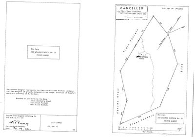 Landmeter-generaal-kaart, 354/1834, 1834
10TRQ701 32 0.jpg
Kadaster
Die Landmeter-generaal se kaartindeks vir hierdie perseel
Navorsingsnotas
[1 Aug 2026] THE MOST-NAMED FARM IN THIS MODEL THAT HAD NO ROW. It appears SIX times in neighbours.csv, on the boundary lists of our own diagrams, and until now had no parcel and therefore no polygon, no page and no way to be clicked. That is the Van Aardsfontein and Klipgat pattern again and it is why LEAD-0059 exists. Matched in the PRINCE ALBERT division, which is ours, so this is not the cross-division name trap that put Haggas 104 km wrong. NO DOCUMENT OF ITS OWN is held: the name, the division and the polygon are all the cadastre's. [TO VERIFY] its number, extent and holders against a diagram.
[7 Aug 2026, SRC-307] THE FARM HAS PEOPLE ON IT NOW, AND THEY ARE THE STORMS. CATHARINA JACOBA MAGDALENA NIEHAUS, wife of HENDRIK JACOBUS STORM, DIED AT THE RESIDENCE AT JAN WILLEMSFONTEIN ON 23 DECEMBER 1862, aged 44, leaving six minor children. Her death notice lists the estate: 114 OXEN, 360 SHEEP, 8 HORSES, a wagon, a cart and household furniture. That is a working farm, not a smallholding. THIS ROW WAS CREATED ON 1 AUG 2026 AS 'the most-named farm in this model that had no row' - a name off six neighbour lists with a polygon and nothing else. It now has a household, a date and an inventory. AND IT SITS 17 KM FROM THE VARSCHE FONTEIN CEMETERY, where two Storms were buried in 1848 and 1849. A Storm household farming at Jan Willems Fontein in 1862 does not prove they were on Varsche Fontein fourteen years earlier, but it is the first ground in this district this project can put a Storm on. LEAD-0124. [TO VERIFY] whether the Storms held title or were farming it for somebody else; this parcel still has no document and no ownership row.
[9 Aug 2026, SRC-349/DOC-0261] THE DIAGRAM ARRIVED AND THIS ROW WAS PINNED TO THE WRONG POLYGON. S.G. Dgm 354/1834 gives the farm as 7,059 MORGEN, about 6,046 ha. This row carried the cadastral key for JAN WILLEMS FONTEIN PORTION 1, 1,824 ha, while calling itself the farm and leaving the portion column blank - which is what checks.py has been reporting as an error since the row was made. The key is now the whole farm, W052C061000000000032000000, 7,703.6 ha. WHY THE MATCHER PICKED THE PORTION: in the cadastre's portions layer this parcel is tagged '1/32', not '32', so a search for the farm number alone finds the portion and not the farm. The farms layer holds the whole farm under '32' and was not the layer consulted. THE 1834 GRANT AND THE MODERN FARM DO NOT AGREE: 6,046 ha against 7,703.6 ha, about 27% more today. That is the opposite of the resurvey-shrinks pattern seen on Klaarstroom 178, so it is not the same story and should not be told as one. [TO VERIFY] against Subst. Dgm 2014/1921 - LEAD-0146. THE 1834 BOUNDARY LIST IS NOW IN neighbours.csv: N the Bank, S Abraham's Kraal, E Plaat Fontein, W Kruid Fontein. Abraham's Kraal is PAR-000030 and the two diagrams agree reciprocally - PAR-000030's own list already put Jan Willems Fontein on its north. PLAAT FONTEIN IS THE FIND. This project holds it as PAR-000017, 'Plaat Fontein (Varsche Fontein Ptn 3)', titled on SG Dgm A191/1923. The 1834 sheet names the ground Plaat Fontein EIGHTY-NINE YEARS before the diagram that made it a portion, which is 5 exactly: the name is older than the title. Whether the 1834 ground and the 1923 portion are the same piece is [TO VERIFY]; they are linked here because the model already held the reverse edge and the geometry supports it. 'The Bank' is recorded as the sheet writes it. It may be a farm name or a landform and this record does not say which.
Werknotas, hier gewys omdat dit 'n private navorsingsbou is.
Die werksnotas op hierdie werf word in Engels gehou en word nie vertaal nie. Hulle verander met elke navorsingsessie, en 'n vertaling sou uit pas raak met die oorspronklike. Alles anders - die stories, die getranskribeerde dokumente en die koppelvlak - is in Afrikaans.
Oop vrae
-
Two Storms on Varsche Fontein, 1848 and 1849 - who were they, and what put them there?
prioriteit 1 · LEAD-0124
Who is the B. STORM buried on Varsche Fontein in 1848 (GRV-0030), and does the grave connect to either of the two Storm lines this family already touches?
Wat dit sou uitmaak THE LIQUIDATION AND DISTRIBUTION ACCOUNT OF MAGDALENA STORM BORN BOTES, died Prince Albert 10 April 1884. Her death notice says she left IMMOVEABLE PROPERTY to be 'all sold immediately and the account filed'. That account names the land. It is now the single most direct route to whether the Storms held ground on or near Varsche Fontein. Failing that, the estate papers of her husband, died Prince Albert 19 August 1855.
-
Three farms are drawn as one of their own portions
prioriteit 2 · LEAD-0100
PAR-000050 Angeliersbosch, PAR-000059 Vlakfontein (Koup) and PAR-000126 Jan Willems Fontein No. 32 are each pinned to a PORTION polygon while the cadastre also holds a whole-farm polygon for the same number. Is the pin wrong, or does each row genuinely mean that portion?
Wat dit sou uitmaak Frans, or a document that ties one of these three rows to a specific portion. The evidence for the whole farm is already in the rows' own notes; what is missing is the decision, because re-pinning changes what the map draws.
-
Substituting Diagram 2014/1921 cancelled the 1834 grant of Jan Willems Fontein, and the farm grew by a quarter
prioriteit 2 · LEAD-0146
S.G. Dgm 354/1834 gives Jan Willems Fontein No. 32 as 7,059 morgen, about 6,046 ha. The modern whole-farm polygon is 7,703.6 ha. The 1834 sheet is stamped CANCELLED, vide Subst. Dgm 2014/1921, D/T 1922-50-2887. What did the 1921 resurvey do, and where did the extra ground come from?
Wat dit sou uitmaak Diagram 2014/1921, which will state the resurveyed extent and name what was taken in.
-
Three more index lines: an insolvent Storm on Willems Kraal, a Botes widow selling Schoorsteen, and a du Pisani field cornet of Traka
prioriteit 2 · LEAD-0191
Three NAAIRS entries Who are they, and does any of them belong in this record?
Wat dit sou uitmaak The files. Each is an index line naming people this record cannot yet place.
Wat die rekord kortkom
-
“Kruid Fontein” is named as a neighbour 2 times and we hold no parcel for it
third order · B3 unheld-farm
2 separate surveys in this model put Kruid Fontein on the boundary of ground we do hold (PAR-000030, PAR-000126). It has no parcel of its own here, so nothing is known about who held it or when, while it borders farms at the centre of the project.
What would settle it The Surveyor-General's farm index for the registration division will give it a farm number and a diagram; the cadastre pull in `fetch_cadastre.py` then places it on the map.
-
Nobody is on record as ever having held this
third order · B8 never-held
Jan Willems Fontein Nr. 32 is in the model and drawn on the map, and carries no ownership record of any kind, not a grant, not a transfer, not an occupation.
What would settle it The Surveyor-General's diagram for the farm number names the grantee and the date; the deed reference on it opens the transfer chain.
Found by breaks.py reading the model against itself, not written by hand,
each one is a shape of missing record, not a fault in the data.
The whole set is on the
questions page.