Roodeklip Nr. 26 (Uniondale)
· op rekord 1832 · wys op die kaart
- Plaasnommer
- Nr. 26
- Moderne opgemete oppervlakte
- 1825.9 ha
Waarom hierdie plaas hier is
Hier omdat 'n oop vraag in hierdie rekord daaroor gaan; wie hierdie grond gehou het, is nog nie vasgestel nie. 80 km van Klaarstroom.
- dokument 'n Dokument in die versameling beskryf hierdie grond DOC-0359
- dokument 'n Dokument in die versameling beskryf hierdie grond DOC-0360
- leidraad 'n Oop vraag in hierdie rekord gaan oor hierdie grond Read KAB CO 4008 p.32 and CO 4044 p.64 - the Roode Klip memorials that name Salomon Terblans, the Erasmus brothers and 'Mosasfontein'
- leidraad 'n Oop vraag in hierdie rekord gaan oor hierdie grond Antoniesberg farms of 1850 not yet on the map: Dwaas, Wanhoop, Naugasfontein, Klein Grobbe
Wat die rekord hou, in volgorde
- 1832 document SG diagram 352/1832
- 1832 document SG diagram verso 352/1832 (verso)
Ook begrens deur, soos die moderne kadaster dit teken
Grond wat aan hierdie plaas raak op die Landmeter-generaal se huidige poligone en wat geen kaart wat hier gehou word, noem nie. Afgelei uit die meetkunde, nie van 'n dokument afgelees nie.
- E Misgund Nr. 25 (Uniondale)
- SE Farm Nr. 478 (Uniondale)
- S Moerasfontein Nr. 27 (Uniondale)
- S Mordenaarsberg Nr. 81 (Uniondale)
- W Georgida Laagte Nr. 36 (Uniondale)
Dokumente
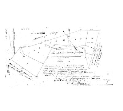 Landmeter-generaal-kaart, 352/1832, 1832
10467436.TIF
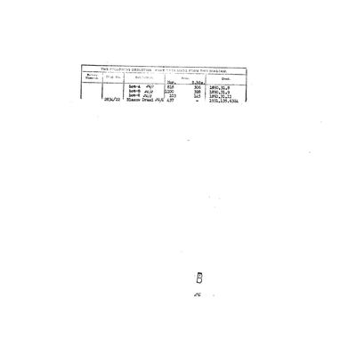 Kaart se keersy, 352/1832 (verso), 1832
10467438.TIF
Kadaster
Die Landmeter-generaal se kaartindeks vir hierdie perseel
Navorsingsnotas
A NEIGHBOUR OF MOERASFONTEIN No. 27 (PAR-000305), whose polygon it touches in the national cadastre; added while tracing de Modder Fonteyn (PAR-000065). PREQUEL GROUND under 9a, never core. Diagram 352/1832 (DOC-0359): 3000 morgen of government ground applied for by SALOMON TERBLANS STEPH:ZN, called Roode Klip; east the place Misgunst, south-west 'Moerasfontyn', lettered 'Loanplace Moerasfontyn' on the face. Geo.Q. 5-42. North of Moerasfontein on the 1880 resurvey (DOC-0344).
[16 Sep 2026] ITS HISTORY FROM THE COLONIAL OFFICE PAPERS, via a 2012 family blog (SRC-650, citing KAB CO 4008 p.32 and CO 4044 p.64, not yet seen): Roode Klip, 9000 morgen, 'contiguous to Mosasfontein, Orgida and Misgunst', held by Salomon Terblans since 30 June 1832 at £2 rent together with 'Oudebos'; sold by Terblans to Stephanus Erasmus, who trekked out of the colony without taking transfer; recommended for forfeiture 11 May 1842; bought 8 December 1842 by Jan (Johan Nicolaas Wilhelm) Barkhuysen from the agent of the late S.P. Erasmus for £284, as 'Rodeklip No 341'; Barkhuysen died there in 1852 and the family still held it in 2012. [TO VERIFY] against the CO originals.
Werknotas, hier gewys omdat dit 'n private navorsingsbou is.
Die werksnotas op hierdie werf word in Engels gehou en word nie vertaal nie. Hulle verander met elke navorsingsessie, en 'n vertaling sou uit pas raak met die oorspronklike. Alles anders - die stories, die getranskribeerde dokumente en die koppelvlak - is in Afrikaans.
Oop vrae
-
Read KAB CO 4008 p.32 and CO 4044 p.64 - the Roode Klip memorials that name Salomon Terblans, the Erasmus brothers and 'Mosasfontein'
prioriteit 1 · LEAD-0352
A 2012 family blog (SRC-650) quotes Colonial Office papers of 1841-1849 on the loan place Roode Klip, 'contiguous to Mosasfontein, Orgida and Misgunst', held by Salomon Terblans from 30 June 1832 with 'Oudebos', sold to Stephanus Erasmus. Do the originals also say who held Moerasfontein, and when it was granted?
Wat dit sou uitmaak A document naming Moerasfontein with its holder in the 1820s-1840s, or its first quitrent title.
-
Antoniesberg farms of 1850 not yet on the map: Dwaas, Wanhoop, Naugasfontein, Klein Grobbe
prioriteit 3 · LEAD-0361
Which modern farm numbers are the 1850 farms around Moerasfontein that J.G. le Roux names and the HSRC map on p. 152 draws, and that the cadastre does not hold under those names? DWAAS is in the CSG index as Dwaas No. 428 (Uniondale), with Dwaasberg No. 414 beside it, but neither is in the provincial cadastre pull. WANHOOP, NAUGASFONTEIN (Frederik Salomon Terblanche, b. 1807, in 1850) and KLEIN GROBBE (Hendrik Johannes Nel) return nothing from the CSG index under any spelling tried (Wan Hoop, Naugas, Noagas, Nougasfontein, Naauwgas, Grobbe, Grobbelaars).
Wat dit sou uitmaak A diagram or quitrent title that gives the 1850 name against a farm number.
Wat die rekord kortkom
-
Nobody is on record as ever having held this
third order · B8 never-held
Roodeklip Nr. 26 (Uniondale) is in the model and drawn on the map, and carries no ownership record of any kind, not a grant, not a transfer, not an occupation.
What would settle it The Surveyor-General's diagram for the farm number names the grantee and the date; the deed reference on it opens the transfer chain.
Found by breaks.py reading the model against itself, not written by hand,
each one is a shape of missing record, not a fault in the data.
The whole set is on the
questions page.