Misgund Nr. 25 (Uniondale)
· op rekord 1832 · wys op die kaart
- Plaasnommer
- Nr. 25
- Ook aangeteken as
- Misgund; Misgunt
- Moderne opgemete oppervlakte
- 3445.2 ha
Waarom hierdie plaas hier is
Hier omdat 'n oop vraag in hierdie rekord daaroor gaan; wie hierdie grond gehou het, is nog nie vasgestel nie. 88 km van Klaarstroom.
- dokument 'n Dokument in die versameling beskryf hierdie grond DOC-0361
- dokument 'n Dokument in die versameling beskryf hierdie grond DOC-0362
- leidraad 'n Oop vraag in hierdie rekord gaan oor hierdie grond The Veldkornetskap Oliphants Rivier farms - is this family tied to any of them beyond its own place?
- leidraad 'n Oop vraag in hierdie rekord gaan oor hierdie grond Antoniesberg farms of 1850 not yet on the map: Dwaas, Wanhoop, Naugasfontein, Klein Grobbe
Wat die rekord hou, in volgorde
- 1832 document SG diagram B354/1832
- 1832 document SG diagram verso B354/1832 (verso)
Ook begrens deur, soos die moderne kadaster dit teken
Grond wat aan hierdie plaas raak op die Landmeter-generaal se huidige poligone en wat geen kaart wat hier gehou word, noem nie. Afgelei uit die meetkunde, nie van 'n dokument afgelees nie.
- SW Mordenaarsberg Nr. 81 (Uniondale)
- SW Farm Nr. 478 (Uniondale)
- W Moerasfontein Nr. 27 (Uniondale)
- W Roodeklip Nr. 26 (Uniondale)
Dokumente
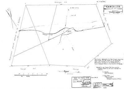 Landmeter-generaal-kaart, B354/1832, 1832
11762976.TIF
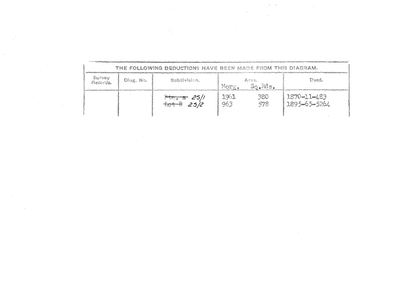 Kaart se keersy, B354/1832 (verso), 1832
11759435.TIF
Kadaster
Die Landmeter-generaal se kaartindeks vir hierdie perseel
Navorsingsnotas
The VELDKORNETSKAP OLIPHANTS RIVIER of the George district, named and listed on George opgaafrol J 91 (SRC-525). Added after that page identified the country the family's Olifants farms lay in. PREQUEL GROUND under 9a - the Oosthuizen road into the Koup - and NEVER `core`, so it must not move the map's opening bounds. Entry 204, held by Anthony Nortje Jr - the son of the widow who holds Wanhoop at entry 203.
[16 Sep 2026] ITS 1832 DIAGRAM READ (DOC-0361, B354/1832): 2995 morgen plus 904 of adjoining government land; WEST 'Government ground applied for by S. Terblans', EAST 'The Farm WANHOOP'; title Geo.Q. 5-44, 30 June 1832. So Wanhoop lay directly east of Misgund. A neighbour of Moerasfontein No. 27 (SRC-649).
Werknotas, hier gewys omdat dit 'n private navorsingsbou is.
Die werksnotas op hierdie werf word in Engels gehou en word nie vertaal nie. Hulle verander met elke navorsingsessie, en 'n vertaling sou uit pas raak met die oorspronklike. Alles anders - die stories, die getranskribeerde dokumente en die koppelvlak - is in Afrikaans.
Oop vrae
-
The Veldkornetskap Oliphants Rivier farms - is this family tied to any of them beyond its own place?
prioriteit 2 · LEAD-0270
Eleven Uniondale farms from the George rolls are now on the map - Nietgenaamd 9, Gorgida 14, Misgund 25, Moerasfontein 27, Keurfontein 45, Wilge River 46, Schoongezigt 52, Roodeheuvel 55, Diepe Kloof 56, Buffels Klip 63, Wilgehoute Rivier 69. *** NOT ONE OF THEM CARRIES A SINGLE OWNERSHIP ROW OR A NAMED HOLDER IN THIS MODEL. *** They are neighbours read off a roll, pinned to a cadastre. Is there any actual family tie to them, or only to Wanhoop and Modderfonteyn?
Wat dit sou uitmaak A named holder on one of those eleven farms who is already a person here, or marries one.
-
Antoniesberg farms of 1850 not yet on the map: Dwaas, Wanhoop, Naugasfontein, Klein Grobbe
prioriteit 3 · LEAD-0361
Which modern farm numbers are the 1850 farms around Moerasfontein that J.G. le Roux names and the HSRC map on p. 152 draws, and that the cadastre does not hold under those names? DWAAS is in the CSG index as Dwaas No. 428 (Uniondale), with Dwaasberg No. 414 beside it, but neither is in the provincial cadastre pull. WANHOOP, NAUGASFONTEIN (Frederik Salomon Terblanche, b. 1807, in 1850) and KLEIN GROBBE (Hendrik Johannes Nel) return nothing from the CSG index under any spelling tried (Wan Hoop, Naugas, Noagas, Nougasfontein, Naauwgas, Grobbe, Grobbelaars).
Wat dit sou uitmaak A diagram or quitrent title that gives the 1850 name against a farm number.
Wat die rekord kortkom
-
Nobody is on record as ever having held this
third order · B8 never-held
Misgund Nr. 25 (Uniondale) is in the model and drawn on the map, and carries no ownership record of any kind, not a grant, not a transfer, not an occupation.
What would settle it The Surveyor-General's diagram for the farm number names the grantee and the date; the deed reference on it opens the transfer chain.
Found by breaks.py reading the model against itself, not written by hand,
each one is a shape of missing record, not a fault in the data.
The whole set is on the
questions page.