Nietgenaamd Nr. 9 (Uniondale)
· op rekord 1802 · wys op die kaart
- Plaasnommer
- Nr. 9
- Ook aangeteken as
- Nietgenaemd of Nooit gedagt; Nooitgedacht; Nietgenaamd
- Moderne opgemete oppervlakte
- 842.4 ha
Waarom hierdie plaas hier is
Hier omdat 'n oop vraag in hierdie rekord daaroor gaan; wie hierdie grond gehou het, is nog nie vasgestel nie. 58 km van Klaarstroom.
- dokument 'n Dokument in die versameling beskryf hierdie grond DOC-0338
- leidraad 'n Oop vraag in hierdie rekord gaan oor hierdie grond The Veldkornetskap Oliphants Rivier farms - is this family tied to any of them beyond its own place?
Wat die rekord hou, in volgorde
- 1802 document SG diagram 82/1802
Dokumente
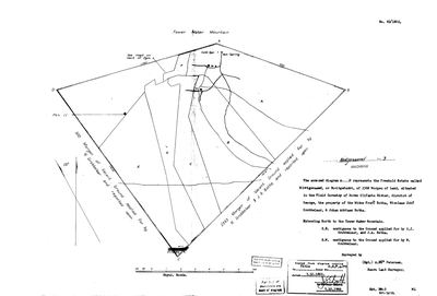 Landmeter-generaal-kaart, 82/1802, 1802
10615693.jpg
Kadaster
Die Landmeter-generaal se kaartindeks vir hierdie perseel
Navorsingsnotas
The VELDKORNETSKAP OLIPHANTS RIVIER of the George district, named and listed on George opgaafrol J 91 (SRC-525). Added after that page identified the country the family's Olifants farms lay in. PREQUEL GROUND under 9a - the Oosthuizen road into the Koup - and NEVER `core`, so it must not move the map's opening bounds. Entry 206, written on the roll as 'Nietgenaemd of Nooit gedagt' - named-not, or never-thought - held by Nic: Joh: Gorbbler with Hen: C: Botha. The cadastre keeps the first of the two names.
*** [20 Aug 2026, SRC-531] ITS 1802 DIAGRAM IS THE OLDEST SURVEY IN THE WHOLE UNIONDALE DIVISION, and for seventeen years the only one. *** SG 82/1802 calls it 'the FREEHOLD ESTATE called Nietgenaamd, or Nooitgedacht', 2368 morgen, in the FIELD CORNETCY OF BOVEN OLIFANTS RIVIER, the property of the widow Fred:k Botha, Nicolaas Joh:s Grobbelaar and Johan Adriaan Botha, surveyed by A. Egidius Petersen. Title O.S.F. 4-79, 9 October 1802.
IT CARRIES A HOT SPRING AND A COLD SPRING at its northern beacon under the TOWER WATER MOUNTAIN - Toorwater - and TOVERWATERS POORT No. 11 lies one kilometre away.
The Olifants River runs at its southern beacon.
The sheet says 'district of George', which did not exist in 1802; the text is typed on a 1966 redrawing and that phrase is the copyist's. In 1802 this was SWELLENDAM.
Werknotas, hier gewys omdat dit 'n private navorsingsbou is.
Die werksnotas op hierdie werf word in Engels gehou en word nie vertaal nie. Hulle verander met elke navorsingsessie, en 'n vertaling sou uit pas raak met die oorspronklike. Alles anders - die stories, die getranskribeerde dokumente en die koppelvlak - is in Afrikaans.
Oop vrae
-
The Veldkornetskap Oliphants Rivier farms - is this family tied to any of them beyond its own place?
prioriteit 2 · LEAD-0270
Eleven Uniondale farms from the George rolls are now on the map - Nietgenaamd 9, Gorgida 14, Misgund 25, Moerasfontein 27, Keurfontein 45, Wilge River 46, Schoongezigt 52, Roodeheuvel 55, Diepe Kloof 56, Buffels Klip 63, Wilgehoute Rivier 69. *** NOT ONE OF THEM CARRIES A SINGLE OWNERSHIP ROW OR A NAMED HOLDER IN THIS MODEL. *** They are neighbours read off a roll, pinned to a cadastre. Is there any actual family tie to them, or only to Wanhoop and Modderfonteyn?
Wat dit sou uitmaak A named holder on one of those eleven farms who is already a person here, or marries one.
Wat die rekord kortkom
-
Nobody is on record as ever having held this
third order · B8 never-held
Nietgenaamd Nr. 9 (Uniondale) is in the model and drawn on the map, and carries no ownership record of any kind, not a grant, not a transfer, not an occupation.
What would settle it The Surveyor-General's diagram for the farm number names the grantee and the date; the deed reference on it opens the transfer chain.
Found by breaks.py reading the model against itself, not written by hand,
each one is a shape of missing record, not a fault in the data.
The whole set is on the
questions page.