Wilge River Nr. 46 (Uniondale)
· op rekord 1832–1894 · wys op die kaart
- Plaasnommer
- Nr. 46
- Ook aangeteken as
- Wilgerivier; Wilge Rivier; Wilge River
- Grootte, soos die kaart dit stel
- 2985 morgen in 1832; 3053 morgen 541 sq roods as resurveyed in 1894
- Moderne opgemete oppervlakte
- 2675.5 ha
Die historiese grootte en die moderne opgemete oppervlakte is twee aparte metings en word hier nie aangebied asof hulle mekaar bevestig nie. Die eerste is wat 'n landmeter op 'n kaart geskryf het, gewoonlik in morg. Die tweede is wat die moderne kadaster teken.
Waarom hierdie plaas hier is
Hier omdat 'n oop vraag in hierdie rekord daaroor gaan; wie hierdie grond gehou het, is nog nie vasgestel nie. 46 km van Klaarstroom.
- dokument 'n Dokument in die versameling beskryf hierdie grond DOC-0331
- dokument 'n Dokument in die versameling beskryf hierdie grond DOC-0332
- leidraad 'n Oop vraag in hierdie rekord gaan oor hierdie grond Which Modder Fonteyn - the Citrusdal farm, or a place of that name in the George district the family was enrolled in in 1816?
- leidraad 'n Oop vraag in hierdie rekord gaan oor hierdie grond The Veldkornetskap Oliphants Rivier farms - is this family tied to any of them beyond its own place?
Wat die rekord hou, in volgorde
- 1832 document SG diagram 340/1832
- 1894 document SG diagram 2439/1894
Ook begrens deur, soos die moderne kadaster dit teken
Grond wat aan hierdie plaas raak op die Landmeter-generaal se huidige poligone en wat geen kaart wat hier gehou word, noem nie. Afgelei uit die meetkunde, nie van 'n dokument afgelees nie.
Dokumente
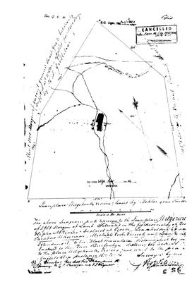 Landmeter-generaal-kaart, 340/1832, 1832
10615655.jpg
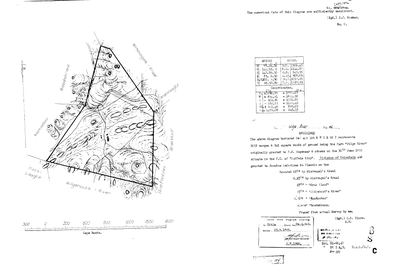 Landmeter-generaal-kaart, 2439/1894, 1894
10DW2V01.jpg
Kadaster
Die Landmeter-generaal se kaartindeks vir hierdie perseel
Navorsingsnotas
Two diagrams sixty-two years apart, SG 340/1832 (DOC-0331, SRC-508) and SG 2439/1894 (DOC-0332, SRC-509). Loan place in 1832, granted to P. J. Wagenaar and others on 30 June 1832, and granted afresh to Jacobus Ludovicus du Plessis by the 1894 survey.
*** THE OLIFANTS RUNS ACROSS THE TOP OF IT, drawn and labelled 'Olephants R. - dry in Summer'. *** *** THE DISTRICT MOVED AND THE GROUND DID NOT, WHICH IS THE POINT FOR LEAD-0220. *** In 1832 this farm is in the FIELDCORNETCY OF BOVEN OLEPHANTS RIVIER, DISTRICT OF GEORGE. In 1894 the same ground is in the F.C. of BUFFELS KLIP, DIVISION OF UNIONDALE. George was cut out of SWELLENDAM on 23 April 1811 (S044), SO BEFORE 1811 THE BOVEN OLIFANTS RIVIER FIELD-CORNETCY WAS SWELLENDAM. That is an inference from two dated documents and not a third document, and it is stated as one.
WHY THAT MATTERS: PAR-000065, de Modder Fonteyn 'gelegen aan d'Olifants rivier', is where Ockert Jacobus OosthuizenL (PER-000118) died in April 1809, and the strongest argument against the southern Olifants has been that the estate was taken before A. A. FAURE, LANDDROST OF SWELLENDAM, whose authority was territorial. THIS PAIR REMOVES THAT OBJECTION: if the Boven Olifants Rivier field-cornetcy was George in 1832 and George was cut from Swellendam in 1811, then in April 1809 it was Swellendam. It does not say which Olifants the farm was on. It says the southern one was reachable. LEAD-0220.
The foot of the 1832 sheet reads 'Loanplace Wilgehoutz rivier, leased by Bokker & VAN TONDER'. [TO VERIFY] - a common surname in this country and no man is identified.
NOT CORE AND NOT IN THE KOUP: no plc_id, so scope.in_koup fails closed.
Werknotas, hier gewys omdat dit 'n private navorsingsbou is.
Die werksnotas op hierdie werf word in Engels gehou en word nie vertaal nie. Hulle verander met elke navorsingsessie, en 'n vertaling sou uit pas raak met die oorspronklike. Alles anders - die stories, die getranskribeerde dokumente en die koppelvlak - is in Afrikaans.
Oop vrae
-
The Veldkornetskap Oliphants Rivier farms - is this family tied to any of them beyond its own place?
prioriteit 2 · LEAD-0270
Eleven Uniondale farms from the George rolls are now on the map - Nietgenaamd 9, Gorgida 14, Misgund 25, Moerasfontein 27, Keurfontein 45, Wilge River 46, Schoongezigt 52, Roodeheuvel 55, Diepe Kloof 56, Buffels Klip 63, Wilgehoute Rivier 69. *** NOT ONE OF THEM CARRIES A SINGLE OWNERSHIP ROW OR A NAMED HOLDER IN THIS MODEL. *** They are neighbours read off a roll, pinned to a cadastre. Is there any actual family tie to them, or only to Wanhoop and Modderfonteyn?
Wat dit sou uitmaak A named holder on one of those eleven farms who is already a person here, or marries one.
-
Which Modder Fonteyn - the Citrusdal farm, or a place of that name in the George district the family was enrolled in in 1816?
prioriteit 3 · LEAD-0220
The 1809 estate inventory places the farm "gelegen aan d'Olifants rivier" and the family knows it as the Modder Fonteyn at what is now Citrusdal. The cadastre put a MODDERFONTEIN A No. 459 four kilometres from Citrusdal and none anywhere in the Koup, and this lead was closed on that. IT IS REOPENED, because the opgaafrol Frans found is a GEORGE district roll of 1816 (SRC-459), the veldcornetcy immediately before the Oosthuizen block is BOVEN OLIFANTS RIVIER - the southern Olifants, which rises on the Traka (SRC-460) - and the landeryen column on the facing page carries an entry reading MODDER FONTYN.
Wat dit sou uitmaak The field cornetcy on the 1808 Swellendam muster roll, J322 - or the farm itself if that roll carries the landeryen column the 1816 George roll does. | THE SWELLENDAM DROSTDY RECORDS (KAB 1/SWM) for 1809 - if the estate passed through that office the district is settled outright, and the same series would give the farm's field cornetcy. | The Cape almanac or government gazette confirming A.A. Faure's office and dates. | The landdrostdij column on image 46 of film 008145125, still unread. | A loan-farm or quitrent entry naming Modder Fonteyn in Swellendam or George.
Wat die rekord kortkom
-
Nobody is on record as ever having held this
third order · B8 never-held
Wilge River Nr. 46 (Uniondale) is in the model and drawn on the map, and carries no ownership record of any kind, not a grant, not a transfer, not an occupation.
What would settle it The Surveyor-General's diagram for the farm number names the grantee and the date; the deed reference on it opens the transfer chain.
Found by breaks.py reading the model against itself, not written by hand,
each one is a shape of missing record, not a fault in the data.
The whole set is on the
questions page.