Vrolykheid Nr. 61 (Tulbagh)
· op rekord 1816 · wys op die kaart
- Plaasnommer
- Nr. 61
- Distrik
- Land van Waveren / Tulbagh
- Grootte, soos die kaart dit stel
- 465 morgen 12 square roods
Hierdie perseel het geen gepaste opmetingspoligoon nie, en kan dus nie op die kaart geteken word nie. Dit is 'n gaping in die kadasterpassing, nie 'n afwesigheid uit die rekord nie.
Waarom hierdie plaas hier is
T.G. Hugo (Vrolykheid, Tulbagh, 1816) het dit gehou, en geen verwantskap met die Oosthuizen, Marincowitz of Van der Merwe-lyne is aangeteken nie. Hierdie grond het deur die grond ingekom, nie deur die familie nie. Nog nie op die kaart geplaas nie.
- storie 'n Geskrewe geskiedenis speel op hierdie grond af Two Vrolykheid farms, far apart?
- storie 'n Geskrewe geskiedenis noem hierdie grond The brother-in-law who founded a town
- dokument 'n Dokument in die versameling beskryf hierdie grond DOC-0074
- dokument 'n Dokument in die versameling beskryf hierdie grond DOC-0116
Stories
- about this farm
Twee Vrolykheid-plase, ver van mekaar?
Twee plase met een naam, 400 km uitmekaar. Die Tulbagh-kaart van 1816 noem vier bure; twee van daardie vanne duik in die Koup op en net EEN hou stand as jy behoorlik kyk. Jan de Bruin, wie se boedel in 1823 'n plaas met die naam Rondabel gehou het, is in 1769 op Tulbagh gedoop. Maar die Theron wat Rondabel in 1868 geneem het, was 'n Roggeveld-man, en daardie draad is 'n toeval van vanne wat hier as een aangemeld word.
- mentions this farm
Die swaer wat 'n dorp gestig het
Twee dogters van Middelwater trou in die 1830's met twee van Zyl-broers. Die een bly. Die ander gaan noord op die trek en is teen omtrent 1840 dood. Haar man leef nog ses-en-sestig jaar en lê op sy plaas Keerom die Vrystaatse dorp Brandfort uit - in druk beskryf as 'n Voortrekker van Prins Albert.
Wat die rekord hou, in volgorde
-
25 Januarie 1816
document
SG diagram 388/1816
Tul.Q.1-23
- 25 Januarie 1816 document SG diagram verso 388/1816 (verso)
-
voor 1816
ownership
T.G. Hugo (Vrolykheid, Tulbagh, 1816)
erfpacht · survey · confidence high
Begrens deur, soos die kaart hulle noem
- N D.T. Theron F.Z. (erfpacht loan-place)
- E T.C. Winterbach (erfpacht loan-place)
- S T. de Bruin (erfpacht loan-place)
- W W. Grobbelaar (erfpacht loan-place)
Dokumente
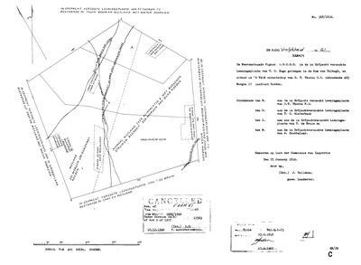 Landmeter-generaal-kaart, 388/1816, 25 Januarie 1816
SCAN676.TIF
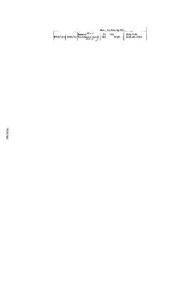 Kaart se keersy, 388/1816 (verso), 25 Januarie 1816
SCAN677.jpg
Navorsingsnotas
[31 Jul 2026] THE OTHER VROLYKHEID. An erfpacht loan-place 'in de Kom van Tulbagh', surveyed 25 Jan 1816 by J. TullekenM on the order of the Commissie van Inspectie, titled Tul.Q.1-23 on 25 Jun 1818 (DOC-0074). It carries the same name as the Koup's Vrolykheid No. 177 (PAR-000014), granted 1841 and about 400 km east - the question of LEAD-0010. This row exists so that lead can be tested against the neighbours rather than retold: it is NOT part of the Karoo land story and does not get grown. Subdivided 1933 into Ptn 1 and Ptn 2 'Vrolikheid Suid' per the verso (DOC-0116); the parent diagram was cancelled 10 Dec 1940 vide dgm 3666/1940 under s24(b) of Act 9 of 1927. No geometry pulled - the WC cadastre pull is scoped to the Prince Albert / Beaufort West registration divisions.
Werknotas, hier gewys omdat dit 'n private navorsingsbou is.
Die werksnotas op hierdie werf word in Engels gehou en word nie vertaal nie. Hulle verander met elke navorsingsessie, en 'n vertaling sou uit pas raak met die oorspronklike. Alles anders - die stories, die getranskribeerde dokumente en die koppelvlak - is in Afrikaans.
Oop vrae
-
Which congregation baptised Jan de Bruijn in 1769?
prioriteit 1 · LEAD-0030
The register page (SRC-168) gives the entry in full but not the church. If it is Roodezand/Tulbagh, the de Bruin family is a Tulbagh family and the Vrolykheid name-transfer of LEAD-0010 has a documented carrier. If it is Drakenstein or Swellendam, it does not.
Wat dit sou uitmaak The waypoint. This is a thirty-second lookup, not a research task.
Wat die rekord kortkom
-
“T.C. Winterbach (erfpacht loan-place)” held ground next door and we have no tenure for them
first order · B4 unheld-owner
A boundary description for Vrolykheid Nr. 61 (Tulbagh) names T.C. WinterbachM (erfpacht loan-place), a surveyor stating on the record that this person held the adjoining ground. No one of that surname holds a single ownership span anywhere in this model.
What would settle it The diagram's own date fixes the window. The quitrent or erfpacht register for that year names the holder of the adjoining place, and an estate inventory will name the farm outright.
-
“W. Grobbelaar (erfpacht loan-place)” held ground next door and we have no tenure for them
first order · B4 unheld-owner
A boundary description for Vrolykheid Nr. 61 (Tulbagh) names W. GrobbelaarM (erfpacht loan-place), a surveyor stating on the record that this person held the adjoining ground. No one of that surname holds a single ownership span anywhere in this model.
What would settle it The diagram's own date fixes the window. The quitrent or erfpacht register for that year names the holder of the adjoining place, and an estate inventory will name the farm outright.
-
The record stops in 1816 and never resumes
second order · B2 trail-ends
Vrolykheid Nr. 61 (Tulbagh) was worked as far as ../1816, with T.G. HugoH (Vrolykheid, Tulbagh, 1816) the last owner on record. 210 years follow with nothing. Who held it after that, and is it still one farm?
What would settle it The current title deed traced backwards, each transfer names the one before it, or the Surveyor-General's subdivision diagrams, which are what usually explain a farm going quiet.
-
“D.T. Theron F.Z. (erfpacht loan-place)” held ground next door and we have no tenure for them
third order · B4 unheld-owner
A boundary description for Vrolykheid Nr. 61 (Tulbagh) names D.T. Theron F.Z.M (erfpacht loan-place), a surveyor stating on the record that this person held the adjoining ground. We do hold Theron tenure elsewhere, but none on this boundary and none at this date.
What would settle it The diagram's own date fixes the window. The quitrent or erfpacht register for that year names the holder of the adjoining place, and an estate inventory will name the farm outright.
-
“T. de Bruin (erfpacht loan-place)” held ground next door and we have no tenure for them
third order · B4 unheld-owner
A boundary description for Vrolykheid Nr. 61 (Tulbagh) names T. de BruinM (erfpacht loan-place), a surveyor stating on the record that this person held the adjoining ground. We do hold De Bruin tenure elsewhere, but none on this boundary and none at this date.
What would settle it The diagram's own date fixes the window. The quitrent or erfpacht register for that year names the holder of the adjoining place, and an estate inventory will name the farm outright.
Found by breaks.py reading the model against itself, not written by hand,
each one is a shape of missing record, not a fault in the data.
The whole set is on the
questions page.