Landmeter-generaal-kaart, 284/1939, Augustus 1938
Landmeter-generaal-kaart, Augustus 1938
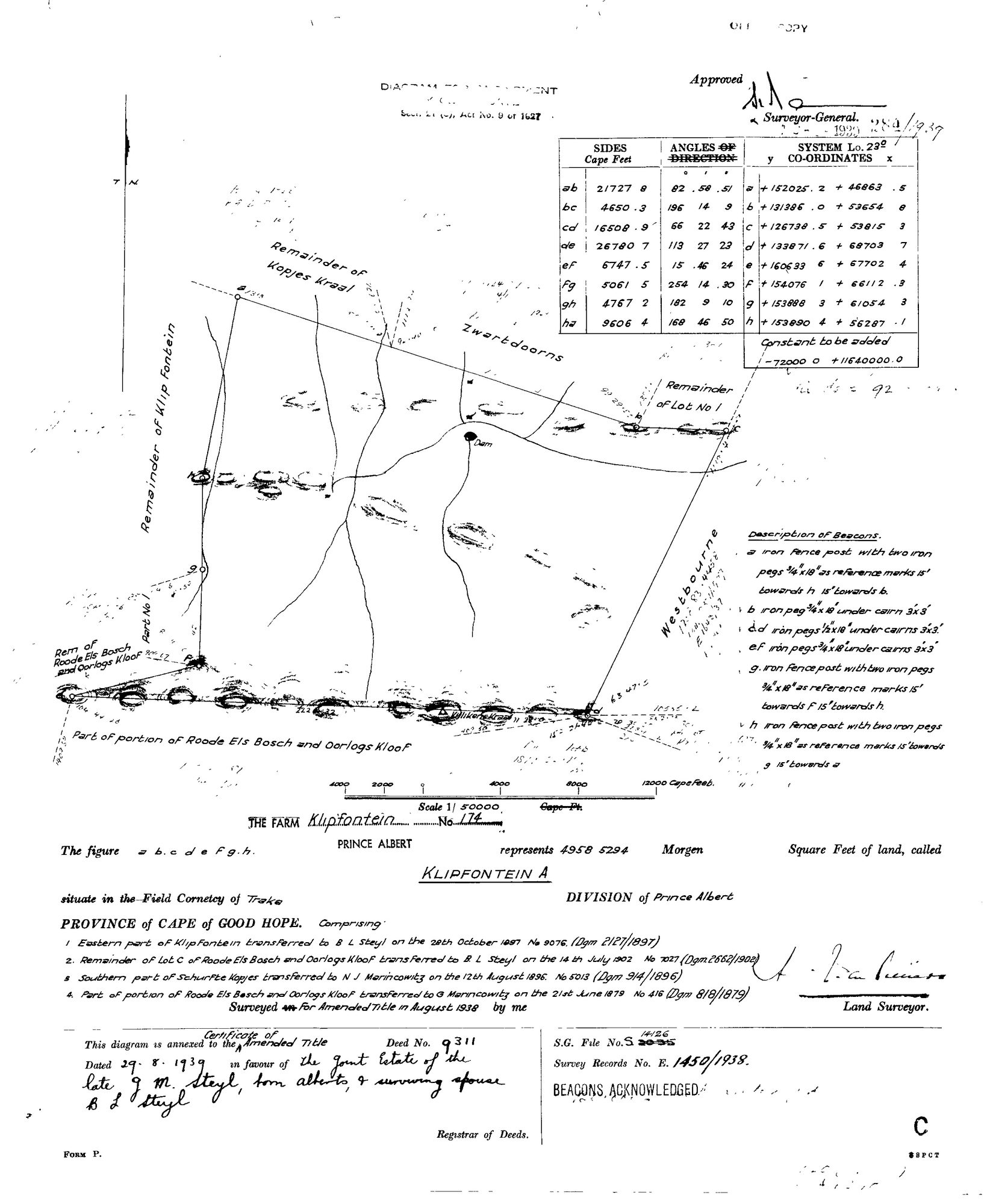
SCAN544.jpg.Die rekord
- Soort
- Landmeter-generaal-kaart
- Kaartnommer
- 284/1939
- Opgemeet
- Augustus 1938
- Getitel
- 29 Augustus 1939
- Akte
- 9311
- Argieflêernaam
- SCAN544.jpg
Sitasie
- Titel
- Klipfontein A, farm No.174, amended-title diagram (1939)
- Bewaarplek
- Surveyor-General
- Verwysing
- SG Dgm 284/1939; S.G. File S.14126; Survey Records E.1450/1938
- Soort
- SG diagram
- Afgehaal
- 2026-07-31
Die grond waaroor dit gaan
Navorsingsnotas
"The figure a b c d e f g h represents 4958.5294 Morgen of land, called KLIPFONTEIN A, the farm Klipfontein No. 174, situate in the Field Cornetcy of Traka, DIVISION of Prince Albert." Diagram for amendment under Act No. 9 of 1927. COMPRISING, verbatim from the sheet: "1 Eastern part of Klipfontein transferred to B L Steyl on the 28th October 1897 No 9076 (Dgm 2127/1897). 2 Remainder of Lot C of Roode Els Bosch and Oorlogs Kloof transferred to B L Steyl on the 14th July 1902 No 1027 (Dgm 2662/1902). 3 Southern part of Schurfte Kopjes transferred to N J Marincowitz on the 12th August 1896 No 5013 (Dgm 914/1896). 4 Part of portion of Roode Els Bosch and Oorlogs Kloof transferred to G Marincowitz on the 21st June 1879 No 416 (Dgm 818/1879)." Surveyed for Amended Title August 1938; annexed to the Certificate of Amended Title deed 9311 dated 29.8.1939 in favour of the joint estate of the late G.M. SteylM, born Alberts, and surviving spouse B.L. Steyl. S.G. File S.14126; Survey Records E.1450/1938; System Lo.23; beacons acknowledged. Drawn neighbours: Remainder of Kopjes Kraal, Zwartdoorns, Remainder of Lot No 1, Westbourne, Remainder of Klip Fontein, Part No 1, Rem of Roode Els Bosch and Oorlogs Kloof. [31 Jul 2026 inbox]
[3 Aug 2026] publish_ok=yes. This is an OLD FARM DIAGRAM held back only because a TRANSFER ENDORSEMENT on its face crosses the 1936 scan cut-off - the survey itself is from the 1920s or 1930s. The names on it are the surveyor, the neighbouring farms and a transferee of the 1930s or 1940, all long dead and most of them already published as person records here. Reviewed individually, not opened as a category.
Die navorsing agter hierdie bladsy, apart gehou daarvan: gedateerde werksnotas, oop vrae, en wat nog nie uitgemaak is nie.
Die werksnotas op hierdie werf word in Engels gehou en word nie vertaal nie. Hulle verander met elke navorsingsessie, en 'n vertaling sou uit pas raak met die oorspronklike. Alles anders - die stories, die getranskribeerde dokumente en die koppelvlak - is in Afrikaans.